IMAGES TAKEN NEAR TO
Ballymaginaghy Road, CASTLEWELLAN, BT31 9BH
Introduction
This page details the photographs taken nearby to Ballymaginaghy Road, BT31 9BH by members of the Geograph project.
The Geograph project started in 2005 with the aim of publishing, organising and preserving representative images for every square kilometre of Great Britain, Ireland and the Isle of Man.

There are currently over 7.5m images from over14,400 individuals and you can help contribute to the project by visiting https://www.geograph.org.uk
Image Map
Images are licensed for reuse under creativecommons.org/licenses/by-sa/2.0
Notes
- Clicking on the map will re-center to the selected point.
- The higher the marker number, the further away the image location is from the centre of the postcode.
Image Listing (3 Images Found)
Images are licensed for reuse under creativecommons.org/licenses/by-sa/2.0
Image
Details
Distance
1
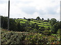
Fields on the slope between Bannanstown Road and Ballymaginaghy Roads
This image was taken from the lower end of Owens Road.
Image: © Eric Jones
Taken: 1 Sep 2011
0.22 miles
2
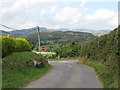
A rural road junction with a view
This is the junction of Owen's Road with the Ballymaginaghy Road. Beyond the Leitrim Valley, the Dromara Hills, topped by Slieve Croob (with the aerials), form the background
Image: © Eric Jones
Taken: 1 Sep 2011
0.23 miles
3
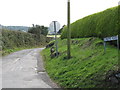
The southern entrance to Owens Road
Owens Road links Ballymaginaghy Road with Bannonstown Road.
Image: © Eric Jones
Taken: 1 Sep 2011
0.24 miles