IMAGES TAKEN NEAR TO
Burrenbridge Road, CASTLEWELLAN, BT31 9AL
Introduction
This page details the photographs taken nearby to Burrenbridge Road, BT31 9AL by members of the Geograph project.
The Geograph project started in 2005 with the aim of publishing, organising and preserving representative images for every square kilometre of Great Britain, Ireland and the Isle of Man.

There are currently over 7.5m images from over14,400 individuals and you can help contribute to the project by visiting https://www.geograph.org.uk
Image Map
Images are licensed for reuse under creativecommons.org/licenses/by-sa/2.0
Notes
- Clicking on the map will re-center to the selected point.
- The higher the marker number, the further away the image location is from the centre of the postcode.
Image Listing (40 Images Found)
Images are licensed for reuse under creativecommons.org/licenses/by-sa/2.0
Image
Details
Distance
1
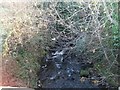
The Burren River below the Burren Bridge on the A25
Image: © Eric Jones
Taken: 12 Dec 2010
0.02 miles
2
The former grocery store and petrol filling station at Burren Bridge
Image: © Eric Jones
Taken: 12 Dec 2010
0.02 miles
4
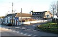
The Bridge Bar at Burrenbridge
This bar appears to be the last surviving enterprise here at the junction of Burrenbridge Road and the A25. Earlier photographs show in addition a grocery store, a petrol station, a garage and a farm food stuffs mill. Plans to redevelop parts of the mill yard for housing were rejected by the Co Down Council in 2007.
Image
Image: © Eric Jones
Taken: 12 Dec 2010
0.04 miles
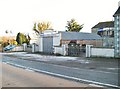
5
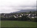
New housing estate in the hamlet of Burrenbridge, near Castlewellan
Image: © Eric Jones
Taken: 17 Jul 2010
0.04 miles
6
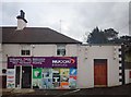
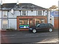
Nucoat Interiors - a paint shop in the village of Burrenbridge
Image: © Eric Jones
Taken: 13 Mar 2018
0.04 miles
7
Burren Bridge Filling Station
On the A25 SW of Castlewellan
Image: © James Carroll
Taken: 26 Mar 2008
0.05 miles
8
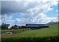
Farmhouse and buildings on the Burrenbridge Road
Image: © Eric Jones
Taken: 14 Apr 2012
0.06 miles
9
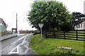
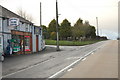
Burrenbridge Road at its junction with the Dublin Road (A25)
Image: © Eric Jones
Taken: 10 Jul 2010
0.06 miles
10
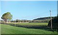
Pasture land and access road at Carrownfreagh Farm
Image: © Eric Jones
Taken: 14 May 2010
0.08 miles