IMAGES TAKEN NEAR TO
Bann Road, CASTLEWELLAN, BT31 9AA
Introduction
This page details the photographs taken nearby to Bann Road, BT31 9AA by members of the Geograph project.
The Geograph project started in 2005 with the aim of publishing, organising and preserving representative images for every square kilometre of Great Britain, Ireland and the Isle of Man.

There are currently over 7.5m images from over14,400 individuals and you can help contribute to the project by visiting https://www.geograph.org.uk
Image Map
Images are licensed for reuse under creativecommons.org/licenses/by-sa/2.0
Notes
- Clicking on the map will re-center to the selected point.
- The higher the marker number, the further away the image location is from the centre of the postcode.
Image Listing (9 Images Found)
Images are licensed for reuse under creativecommons.org/licenses/by-sa/2.0
Image
Details
Distance
1
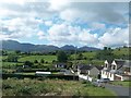
A group of modern houses on the south side of the Castlewellan Road
The High Mournes form the background.
Image: © Eric Jones
Taken: 15 Aug 2014
0.02 miles
2
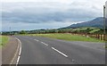
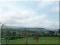
Bend in the Bann Road a mile west of Castlewellan
This bend gives a fine view of the northern flank of the Mournes.
Image: © Eric Jones
Taken: 15 Aug 2014
0.05 miles
3
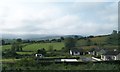
A small rural housing estate south of the Bann Road
Image: © Eric Jones
Taken: 23 Aug 2011
0.06 miles
4
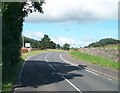
Approaching the Banbridge District Boundary on the Bann Road
The image was taken from the Down District. The Banbridge and Down Districts are two of 26 council areas formed on 1 October 1973. From 2015 Banbridge and Down will disappear as local government areas each being absorbed into much larger units with present boundary being pushed much further west almost to the village of Moneyslane.
Image: © Eric Jones
Taken: 15 Aug 2014
0.09 miles
5
View northwards across farmland from the Dublin Road
The woodlands are those of the Castlewellan Demesne.
Image: © Eric Jones
Taken: 28 May 2010
0.22 miles
6
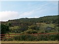
Ruined cottage below Ballymagreehan Wood
Image: © Eric Jones
Taken: 23 Aug 2011
0.22 miles
7
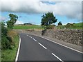
Bend in the Bann Road west of Castlewellan
Image: © Eric Jones
Taken: 15 Aug 2014
0.23 miles
8
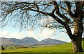
Tree, Castlewellan
A solitary tree, well outside the main part of the forest park. The cragged mountain in the background is Slieve Binnian Image
Image: © Albert Bridge
Taken: 11 Apr 2009
0.24 miles
9
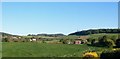
Farmland between the Bann and Dublin Roads
Moneyscalp Woods can be seen in the background.
Image: © Eric Jones
Taken: 23 Aug 2011
0.25 miles