IMAGES TAKEN NEAR TO
The Anchorage, DOWNPATRICK, BT30 9UH
Introduction
This page details the photographs taken nearby to The Anchorage, BT30 9UH by members of the Geograph project.
The Geograph project started in 2005 with the aim of publishing, organising and preserving representative images for every square kilometre of Great Britain, Ireland and the Isle of Man.

There are currently over 7.5m images from over14,400 individuals and you can help contribute to the project by visiting https://www.geograph.org.uk
Image Map
Images are licensed for reuse under creativecommons.org/licenses/by-sa/2.0
Notes
- Clicking on the map will re-center to the selected point.
- The higher the marker number, the further away the image location is from the centre of the postcode.
Image Listing (18 Images Found)
Images are licensed for reuse under creativecommons.org/licenses/by-sa/2.0
Image
Details
Distance
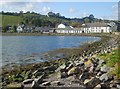
1
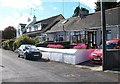
Seaside bungalows at Cuan Beach, Killyleagh
The garden of the bungalow nearest the camera is a delight. Cuan, meaning calm or peaceful, is the Irish name for Strangford Lough.
Image: © Eric Jones
Taken: 13 Oct 2012
0.09 miles
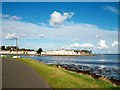
2
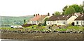
Cuan Beach, Killyleagh
Cuan Beach runs from the bottom of Irish Street, around the loughshore, towards the road to Downpatrick (where it is the Shore Road).
Image: © Albert Bridge
Taken: 18 May 2009
0.12 miles
3
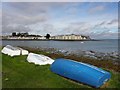
Killyleagh, County Down
Looking north from Cuan Beach at Strangford Lough
Image: © Kenneth Allen
Taken: 8 Oct 2011
0.13 miles
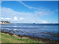
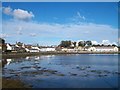
5

View south-eastwards across Killyleagh Harbour
The coast on the far shore is a part of the Lecale Peninsula.
Image: © Eric Jones
Taken: 13 Oct 2012
0.17 miles
9
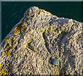
Bench Mark, Killyleagh
Bolt bench mark located on Killyleagh Quay Image This mark dates from the First Geodetic Levelling of Ireland, 1839-43.
The original remarks for the mark describe it as
"Copper bolt driven vertically into stonework, level with surface". The mark was initially levelled to 17.234 feet above sea level.
Today the mark has been levelled to 2.53 metres above MSL.
Image: © Rossographer
Taken: 7 Nov 2014
0.22 miles
10
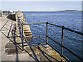
Quayside, Killyleagh
The old quay at Killyleagh. Although the area has been redeveloped Image, the quay dates from the early 1800s - there is an old bench mark from c1840 just below the railings close to the camera position Image
Image: © Rossographer
Taken: 7 Nov 2014
0.22 miles