IMAGES TAKEN NEAR TO
Shrigley Road, DOWNPATRICK, BT30 9SR
Introduction
This page details the photographs taken nearby to Shrigley Road, BT30 9SR by members of the Geograph project.
The Geograph project started in 2005 with the aim of publishing, organising and preserving representative images for every square kilometre of Great Britain, Ireland and the Isle of Man.

There are currently over 7.5m images from over14,400 individuals and you can help contribute to the project by visiting https://www.geograph.org.uk
Image Map
Images are licensed for reuse under creativecommons.org/licenses/by-sa/2.0
Notes
- Clicking on the map will re-center to the selected point.
- The higher the marker number, the further away the image location is from the centre of the postcode.
Image Listing (24 Images Found)
Images are licensed for reuse under creativecommons.org/licenses/by-sa/2.0
Image
Details
Distance
1
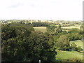
View towards Shrigley from Killyleagh Castle
The fields in the foreground are between Shrigley Road and Comber Road. The chimney at Shrigley visible on the skyline is also seen in Image
Image: © David Hawgood
Taken: 4 Sep 2009
0.07 miles
2
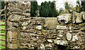
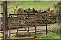
Mary's stile, Killyleagh
Mary’s stile at the entrance to the ruin of Killowen church.
Image: © Albert Bridge
Taken: 12 Mar 2012
0.17 miles
3
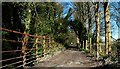
Broad Meadows Lane, Killyleagh
Broad Meadows Lane is a public footpath running from the Shrigley Road to the Comber Road (background). The bridge carries the lane over the Dibney River.
Image: © Albert Bridge
Taken: 5 Apr 2008
0.18 miles
4
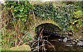
River bridge, Killyleagh
The bridge carrying the path across the Dibney River.
Image: © Albert Bridge
Taken: 12 Mar 2012
0.18 miles
5
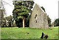
Killowen church, Killyleagh (1)
The ruin seen from the north.
Image: © Albert Bridge
Taken: 12 Mar 2012
0.18 miles
6
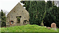
Killowen church, Killyleagh (2)
The ruin seen from the south west.
Image: © Albert Bridge
Taken: 12 Mar 2012
0.18 miles
7
Gate, Killyleagh
The gate which leads from the paved path to a grassy path and Mary’s stile.
Image: © Albert Bridge
Taken: 12 Mar 2012
0.18 miles
8
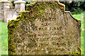
Killowen graveyard, Killyleagh
Inevitably, with the passage of time, headstones succumb to the effects of the weather. Most of the older ones are not now legible. This one, from the 19th century, erected by Sarah Sloan in memory of her husband Patrick, who died at the age of 42 in 1868, is one of the best preserved.
Image: © Albert Bridge
Taken: 12 Mar 2012
0.18 miles
9
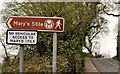
Mary's stile path sign, Killyleagh
The sign at the entrance to the path from the Shrigley Road.
Image: © Albert Bridge
Taken: 12 Mar 2012
0.18 miles
10
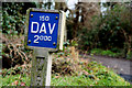
Fire hydrant posts, Killyleagh (2)
DAV post on the Shrigley Road, at the end of the Broad Meadows Lane path.
Image: © Albert Bridge
Taken: 24 Jan 2011
0.19 miles