IMAGES TAKEN NEAR TO
Breakeys Brae, DOWNPATRICK, BT30 9QD
Introduction
This page details the photographs taken nearby to Breakeys Brae, BT30 9QD by members of the Geograph project.
The Geograph project started in 2005 with the aim of publishing, organising and preserving representative images for every square kilometre of Great Britain, Ireland and the Isle of Man.

There are currently over 7.5m images from over14,400 individuals and you can help contribute to the project by visiting https://www.geograph.org.uk
Image Map
Images are licensed for reuse under creativecommons.org/licenses/by-sa/2.0
Notes
- Clicking on the map will re-center to the selected point.
- The higher the marker number, the further away the image location is from the centre of the postcode.
Image Listing (148 Images Found)
Images are licensed for reuse under creativecommons.org/licenses/by-sa/2.0
Image
Details
Distance
1
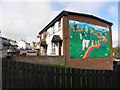
Football mural, Killyleagh
It is located along Frederick Street
Image: © Kenneth Allen
Taken: 8 Oct 2011
0.02 miles
2
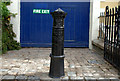
Old boundary post, Killyleagh
Old boundary post outside a house in High Street. The inscription reads:
“Parliamentary and municipal boundary of Belfast Victoria Division Victoria Ward 1918”.
Image: © Albert Bridge
Taken: 17 May 2010
0.02 miles
3
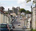
Frederick Street and castle, Killyleagh
View from Church Hill. The part of the castle seen at the end of the street is a war memorial - the wreaths of poppies hanging on the tower are visible.
Image: © David Hawgood
Taken: 4 Sep 2009
0.03 miles
4
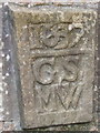
Stone from birthplace of Sir Hans Sloane at Killyleagh
This stone inscribed "1637 GS MW" was part of the house where Sir Hans Sloane was born. When the area was redeveloped the stone was built into a wall nearby with a commemorative plaque.
Image: © David Hawgood
Taken: 4 Sep 2009
0.03 miles
5
Sign for Stranford Lough Cycle Trail at Killyleagh
The sign is for National Cycle Network route 99, showing 19 miles to Comber and 23 to Newtownards. The trail goes around Stranford Lough, with a connection to Belfast.
Image: © David Hawgood
Taken: 4 Sep 2009
0.04 miles
6
Dufferin Coaching Inn , Killyleagh
Part of the inn was formerly the Ulster Bank and still has its sign on the window. The inn has a surprisingly large banqueting hall; we enjoyed a cream tea there on our group tour of Killyleagh. See http://www.dufferincoachinginn.com/.
Image: © David Hawgood
Taken: 4 Sep 2009
0.04 miles
7
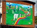
Football mural, Killyleagh (1)
See Image Mural, at Braeside Gardens/Frederick Street, commemorating three Northern Ireland internationals from Killyleagh. Continue to Image
Image: © Albert Bridge
Taken: 17 May 2010
0.04 miles
8

Football mural, Killyleagh (2)
See Image David Healy.
Image: © Albert Bridge
Taken: 17 May 2010
0.04 miles
9
Derelict property in Dufferin Place, Killyleagh
Image: © Eric Jones
Taken: 13 Oct 2012
0.05 miles
10
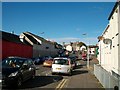
View north along Dufferin Place, Killyleagh
Image: © Eric Jones
Taken: 13 Oct 2012
0.05 miles