IMAGES TAKEN NEAR TO
Tullymacnous Road, DOWNPATRICK, BT30 9PW
Introduction
This page details the photographs taken nearby to Tullymacnous Road, BT30 9PW by members of the Geograph project.
The Geograph project started in 2005 with the aim of publishing, organising and preserving representative images for every square kilometre of Great Britain, Ireland and the Isle of Man.

There are currently over 7.5m images from over14,400 individuals and you can help contribute to the project by visiting https://www.geograph.org.uk
Image Map
Images are licensed for reuse under creativecommons.org/licenses/by-sa/2.0
Notes
- Clicking on the map will re-center to the selected point.
- The higher the marker number, the further away the image location is from the centre of the postcode.
Image Listing (2 Images Found)
Images are licensed for reuse under creativecommons.org/licenses/by-sa/2.0
Image
Details
Distance
1
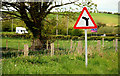
"Junction on bend" sign near Killyleagh
On the Clea Lough Road Image (looking towards Derryboye). The road to the right is the Tullymacnous Road Image The position of the BT van, in relation to the sign, gives an indication of the bend’s curve.
Image: © Albert Bridge
Taken: 17 May 2010
0.19 miles
2
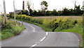
The Clea Lough Road near Killyleagh
A twisting and undulating “B” class road, running through the east Down drumlins from Derryboye, past the Clea Lakes Image, to Shrigley. The chimney of Shrigley mill Image can be seen at top left.
Image: © Albert Bridge
Taken: 17 May 2010
0.23 miles