IMAGES TAKEN NEAR TO
Rademon Court, DOWNPATRICK, BT30 9NS
Introduction
This page details the photographs taken nearby to Rademon Court, BT30 9NS by members of the Geograph project.
The Geograph project started in 2005 with the aim of publishing, organising and preserving representative images for every square kilometre of Great Britain, Ireland and the Isle of Man.

There are currently over 7.5m images from over14,400 individuals and you can help contribute to the project by visiting https://www.geograph.org.uk
Image Map
Images are licensed for reuse under creativecommons.org/licenses/by-sa/2.0
Notes
- Clicking on the map will re-center to the selected point.
- The higher the marker number, the further away the image location is from the centre of the postcode.
Image Listing (48 Images Found)
Images are licensed for reuse under creativecommons.org/licenses/by-sa/2.0
Image
Details
Distance
1
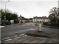
The junction of the Killyleagh Road and the A7 in the centre of Crossgar
The bridge carries the A7 over the Glasswater River. The Glasswater River is a tributary of the Quoile.
Image: © Eric Jones
Taken: 25 Nov 2015
0.05 miles
2
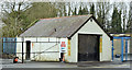
Vacant building, Crossgar (February 2016)
A vacant building, recently used as a car wash, on the Ballynahinch Road, beside St Joseph’s Primary School (right).
Image: © Albert Bridge
Taken: 17 Feb 2016
0.06 miles
3
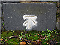
Bench Mark, Crossgar
Cut bench mark on Everogue's Bridge, Crossgar.
The mark is 18.48 metres above MSL.
Image: © Rossographer
Taken: 23 Oct 2010
0.06 miles
4
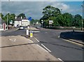
The A7 (Downpatrick Road) at the junction with Ballynahinch Road and Killyleagh Road, Crossgar
Image: © Eric Jones
Taken: 2 Aug 2013
0.07 miles
5
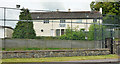
Former police station, Crossgar
The former Crossgar police station, on the Saintfield Road, postdates the Rippingham era Image It was a standard design which included living accommodation before that became unsafe. Now closed and offered for sale. The agents’ board describes it as “Excellent residential/commercial development opportunity (subject to planning) c 0.42 acres”. This photograph appears as a matter of record only. I have no connection with any of the parties involved in the sale. Continue to Image
Image: © Albert Bridge
Taken: 13 Jun 2013
0.07 miles
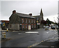
6

Former police station, Crossgar (February 2016)
See Image (June 2013). The building is the subject of the following application for planning permission - 23 October 2015 “LA07/2015/1124/F Change of use of part of former police station offices and former police house accommodation into residential use, with an additional proposed first floor extension on the flat roof of former cells and changing room 6 Saintfield Road Crossgar Downpatrick BT30 9HY”. This photograph appears as a matter of record only and does not express any opinion about the application.
Image: © Albert Bridge
Taken: 17 Feb 2016
0.07 miles
7
The Kilmore Road, Crossgar
The Crossgar end of the minor road from Kilmore Image
Image: © Albert Bridge
Taken: 13 Jun 2013
0.08 miles
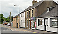
9
Downpatrick Street, Crossgar
The junction of Downpatrick Street (ahead) and Killyleagh Street (left) in Crossgar.
Image: © Rossographer
Taken: 23 Oct 2010
0.09 miles
10
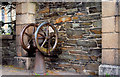
Old pump, Crossgar
The same pump, with hand wheel, previously seen in Image I’d hoped that it might have an inscription showing the maker’s name or date of manufacture but, if it does, I couldn’t find one.
Image: © Albert Bridge
Taken: 25 Mar 2011
0.10 miles