IMAGES TAKEN NEAR TO
Ballylucas Road, DOWNPATRICK, BT30 8SY
Introduction
This page details the photographs taken nearby to Ballylucas Road, BT30 8SY by members of the Geograph project.
The Geograph project started in 2005 with the aim of publishing, organising and preserving representative images for every square kilometre of Great Britain, Ireland and the Isle of Man.

There are currently over 7.5m images from over14,400 individuals and you can help contribute to the project by visiting https://www.geograph.org.uk
Image Map
Images are licensed for reuse under creativecommons.org/licenses/by-sa/2.0
Notes
- Clicking on the map will re-center to the selected point.
- The higher the marker number, the further away the image location is from the centre of the postcode.
Image Listing (8 Images Found)
Images are licensed for reuse under creativecommons.org/licenses/by-sa/2.0
Image
Details
Distance
1
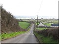
The Ballylucas Road descending towards Minerstown
The road here is descending down the blunt end of a drumlin.
Image: © Eric Jones
Taken: 7 Feb 2012
0.05 miles
2
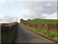
The Ballylucas Road ascending towards Scollogstown
An Anglo-Norman motte, built on the site of an earlier rath, can be seen on the top of the drumlin.
Image: © Eric Jones
Taken: 7 Feb 2012
0.07 miles
3
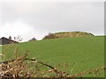
Motte on the Ballylucas Road
This is an Anglo-Norman motte built on the site of an earlier Irish rath. Pottery finds at this site have included 13thC English made pottery.
Image: © Eric Jones
Taken: 7 Feb 2012
0.16 miles
5
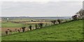
View southeastwards towards the coast from the Ballylucas Road
St John's Point, with its familiar light house, can be seen in the background.
Image: © Eric Jones
Taken: 7 Feb 2012
0.20 miles
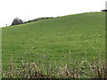
6
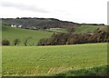
Drumlins between Orchard Road and Ballylucas Road
These drumlins which support good pasture contrast with the rocky ridges north of Orchard Road much of which are covered in whins.
Image: © Eric Jones
Taken: 7 Feb 2012
0.20 miles
7
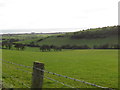
Valley between drumlins viewed from the Ballylucas Road
These drumlins lie at right angle to the coast.
Image: © Eric Jones
Taken: 7 Feb 2012
0.21 miles
8
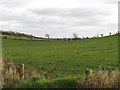
Sloping drumlin land south of Orchard Road
Image: © Eric Jones
Taken: 7 Feb 2012
0.23 miles