IMAGES TAKEN NEAR TO
Newcastle Road, DOWNPATRICK, BT30 8SQ
Introduction
This page details the photographs taken nearby to Newcastle Road, BT30 8SQ by members of the Geograph project.
The Geograph project started in 2005 with the aim of publishing, organising and preserving representative images for every square kilometre of Great Britain, Ireland and the Isle of Man.

There are currently over 7.5m images from over14,400 individuals and you can help contribute to the project by visiting https://www.geograph.org.uk
Image Map
Images are licensed for reuse under creativecommons.org/licenses/by-sa/2.0
Notes
- Clicking on the map will re-center to the selected point.
- The higher the marker number, the further away the image location is from the centre of the postcode.
Image Listing (3 Images Found)
Images are licensed for reuse under creativecommons.org/licenses/by-sa/2.0
Image
Details
Distance
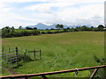
3
View WNW across farmland towards a farmhouse on Cumran Lane
The Slieve Croob Range can be seen in the background. The image was taken from the A24.
Image: © Eric Jones
Taken: 7 Dec 2018
0.19 miles