IMAGES TAKEN NEAR TO
Downpatrick Road, DOWNPATRICK, BT30 8LQ
Introduction
This page details the photographs taken nearby to Downpatrick Road, BT30 8LQ by members of the Geograph project.
The Geograph project started in 2005 with the aim of publishing, organising and preserving representative images for every square kilometre of Great Britain, Ireland and the Isle of Man.

There are currently over 7.5m images from over14,400 individuals and you can help contribute to the project by visiting https://www.geograph.org.uk
Image Map
Images are licensed for reuse under creativecommons.org/licenses/by-sa/2.0
Notes
- Clicking on the map will re-center to the selected point.
- The higher the marker number, the further away the image location is from the centre of the postcode.
Image Listing (15 Images Found)
Images are licensed for reuse under creativecommons.org/licenses/by-sa/2.0
Image
Details
Distance
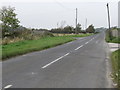
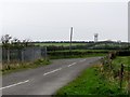
1
The Ballygilbert road junction on the Downpatrick Road (B176)
Image: © Eric Jones
Taken: 22 Jul 2013
0.02 miles
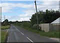
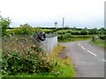
2
The Ballygilbert Road turn-off on the Downpatrick Road
Image: © Eric Jones
Taken: 28 Sep 2011
0.03 miles
3
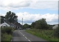
Bungalows on the Downpatrick Road, Killough
These are located just south of the Ballygilbert Road junction.
Image: © Eric Jones
Taken: 22 Jul 2013
0.05 miles
5
The entrance to Ballygilbert Road from the Downpatrick Road
The Ballygilbert Water Tower can be seen in the background.
Image: © Eric Jones
Taken: 20 Jul 2011
0.08 miles
6
The Downpatrick Road running alongside the Ballygilbert Reservoir
Image: © Eric Jones
Taken: 22 Jul 2013
0.10 miles
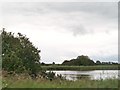
7
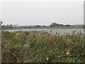
The north reservoir at Ballygilbert
The two reservoirs (north and south) the brackish Strand Lough and the coastal mudflats are parts of the Killough ASSI.
http://www.doeni.gov.uk/niea/protected_areas_home/new_assi_landing_page/county_down-2/killough_bay_and_strand_lough_assi.htm
Image: © Eric Jones
Taken: 28 Sep 2011
0.10 miles
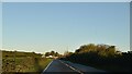
8
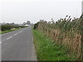
The Downpatrick Road at Ballygilbert
This is the B176. It is used by the 16A service between Downpatrick, Killough, Ardglass and Ballyhornan. The hedge on the right separates the road from the Ballygilbert reservoir.
Image: © Eric Jones
Taken: 28 Sep 2011
0.12 miles
9
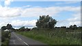
Farmland south of the Ballygilbert Road
The land rises south of the road. The hill is topped by the Ballygilbert Water Tower which is in the neighbouring square. This is an area mainly of pastoral farming.
Image: © Eric Jones
Taken: 28 Sep 2011
0.12 miles
10
Ballygilbert Reservoir from the Downpatrick Road
Image: © Eric Jones
Taken: 20 Jul 2011
0.14 miles