IMAGES TAKEN NEAR TO
Loughinisland Road, DOWNPATRICK, BT30 8JJ
Introduction
This page details the photographs taken nearby to Loughinisland Road, BT30 8JJ by members of the Geograph project.
The Geograph project started in 2005 with the aim of publishing, organising and preserving representative images for every square kilometre of Great Britain, Ireland and the Isle of Man.

There are currently over 7.5m images from over14,400 individuals and you can help contribute to the project by visiting https://www.geograph.org.uk
Image Map
Images are licensed for reuse under creativecommons.org/licenses/by-sa/2.0
Notes
- Clicking on the map will re-center to the selected point.
- The higher the marker number, the further away the image location is from the centre of the postcode.
Image Listing (3 Images Found)
Images are licensed for reuse under creativecommons.org/licenses/by-sa/2.0
Image
Details
Distance
1
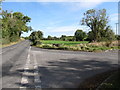
The junction of Loughinisland and Woodgrange Road
This junction is in the Broaghclogh or Murvaclocher TD.
Image: © Eric Jones
Taken: 2 Oct 2014
0.19 miles
2
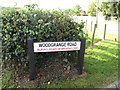
Road name plate at the northern end of Woodgrange Road
The red lettering on the sign shows the name of the townland i.e. Murvaclogher or Broaghclogh. This townland is within the parish of Kilmore
Image: © Eric Jones
Taken: 2 Oct 2014
0.19 miles
3
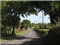
Loughinisland Road approaching the junction with Woodgrange Road
Image: © Eric Jones
Taken: 2 Oct 2014
0.19 miles