IMAGES TAKEN NEAR TO
Ballynoe Road, DOWNPATRICK, BT30 8AR
Introduction
This page details the photographs taken nearby to Ballynoe Road, BT30 8AR by members of the Geograph project.
The Geograph project started in 2005 with the aim of publishing, organising and preserving representative images for every square kilometre of Great Britain, Ireland and the Isle of Man.

There are currently over 7.5m images from over14,400 individuals and you can help contribute to the project by visiting https://www.geograph.org.uk
Image Map
Images are licensed for reuse under creativecommons.org/licenses/by-sa/2.0
Notes
- Clicking on the map will re-center to the selected point.
- The higher the marker number, the further away the image location is from the centre of the postcode.
Image Listing (7 Images Found)
Images are licensed for reuse under creativecommons.org/licenses/by-sa/2.0
Image
Details
Distance
1
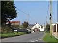
Entering the village of Ballynoe along the Ballylucas Road
Image: © Eric Jones
Taken: 28 Sep 2011
0.10 miles
2
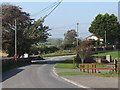
The junction of the Ballynoe and Ballylucas Roads
This junction is at the southern end of the village of Ballynoe.
Image: © Eric Jones
Taken: 28 Sep 2011
0.13 miles
3
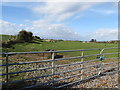
The former track bed of the Downpatrick, Killough and Ardglass Railway west of Ballynoe Road
Opened in 1890 this branch line was built mainly to serve the fishing industry at Ardglass.
Image: © Eric Jones
Taken: 2 Oct 2014
0.18 miles
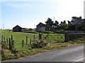
4
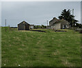
Former Ballynoe Railway Station
The former station at Ballynoe - the line from Downpatrick to Ardglass (ahead) ran right through here. The old goods shed is on the left.
Image: © Rossographer
Taken: 5 Oct 2022
0.18 miles
5
The former Ballynoe Railway Station
Opened by the Downpatrick, Killough and Ardglass Railway in the 1890s, it was later taken over by the Belfast and County Down Railway. It was closed in 1950.
Image: © Eric Jones
Taken: 2 Oct 2014
0.19 miles
6
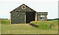
Former Ballynoe station near Downpatrick
For the background to the Ardglass branch see Image This is the former goods shed at Ballynoe – in very good condition 58 years after the line closed.
Image: © Albert Bridge
Taken: 7 Jul 2008
0.20 miles
7
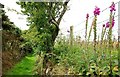
Public lane to Ballynoe Stone Circle
This lane is the public access to Ballynoe Stone Circle Image There is a private lane Image behind the fence on the right.
Image: © Albert Bridge
Taken: 7 Jul 2008
0.23 miles