IMAGES TAKEN NEAR TO
St. Nicholas Walk, DOWNPATRICK, BT30 7UT
Introduction
This page details the photographs taken nearby to St. Nicholas Walk, BT30 7UT by members of the Geograph project.
The Geograph project started in 2005 with the aim of publishing, organising and preserving representative images for every square kilometre of Great Britain, Ireland and the Isle of Man.

There are currently over 7.5m images from over14,400 individuals and you can help contribute to the project by visiting https://www.geograph.org.uk
Image Map
Images are licensed for reuse under creativecommons.org/licenses/by-sa/2.0
Notes
- Clicking on the map will re-center to the selected point.
- The higher the marker number, the further away the image location is from the centre of the postcode.
Image Listing (60 Images Found)
Images are licensed for reuse under creativecommons.org/licenses/by-sa/2.0
Image
Details
Distance
1
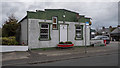
The Shield Hall, Ardglass
Old hall on High Street, Ardglass. It now appears to be part of a shop.
Image: © Rossographer
Taken: 23 Aug 2020
0.09 miles
2
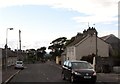
Houses near the Chapel in the High Street, Ardglass
Image: © Eric Jones
Taken: 22 Jul 2013
0.09 miles
3
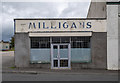
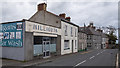
Vacant shop, Ardglass
The former Milligan's store on High Street, Ardglass - although I think it has moved to new premises nearby.
Image: © Rossographer
Taken: 23 Aug 2020
0.09 miles
4
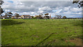
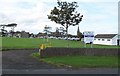
Playing fields, Ardglass
Playing fields off the Green Road in Ardglass.
Image: © Rossographer
Taken: 23 Aug 2020
0.10 miles
5
High Street, Ardglass
High Street in Ardglass.
Image: © Rossographer
Taken: 23 Aug 2020
0.10 miles
6
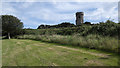
Isabella's Tower, Ardglass
Isabella's Tower on a hill on the southern edge of Ardglass. I couldn't get any closer as it is surrounded by thick vegetation. See also Image
The tower was also used as a triangulation station by OSNI and is one of only two stations not marked by a triangulation pillar. I suspect there is a bolt/rivet somewhere near the top.
Image: © Rossographer
Taken: 23 Aug 2020
0.11 miles
7
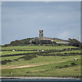
Isabella's Tower, Ardglass
Isabella's Tower on a hill on the southern edge of Ardglass. This is the view from Killough. See also Image
The tower was also used as a triangulation station by OSNI and is one of only two stations not marked by a triangulation pillar. I suspect there is a bolt/rivet somewhere near the top.
Image: © Rossographer
Taken: 23 Aug 2020
0.11 miles
9
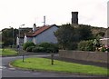
Ward Close and Isabella's Tower
Isabella's Tower stands on the highest point in Ardglass and is a well known local landmark. It is a folly built in the 19thC by Aubrey de Vere Beauclerc for his crippled daughter, Isabella. Later, it became a lookout for the Coastguard. It has since been converted into a private residence.
Image: © Eric Jones
Taken: 20 Aug 2009
0.11 miles
10
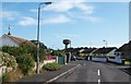
View along the Green Road in the direction of the Ardglass Water Tower
Set on a hill, this tower can be seen for miles around
Image: © Eric Jones
Taken: 20 Aug 2009
0.11 miles