IMAGES TAKEN NEAR TO
Kildare Place, DOWNPATRICK, BT30 7TT
Introduction
This page details the photographs taken nearby to Kildare Place, BT30 7TT by members of the Geograph project.
The Geograph project started in 2005 with the aim of publishing, organising and preserving representative images for every square kilometre of Great Britain, Ireland and the Isle of Man.

There are currently over 7.5m images from over14,400 individuals and you can help contribute to the project by visiting https://www.geograph.org.uk
Image Map
Images are licensed for reuse under creativecommons.org/licenses/by-sa/2.0
Notes
- Clicking on the map will re-center to the selected point.
- The higher the marker number, the further away the image location is from the centre of the postcode.
Image Listing (89 Images Found)
Images are licensed for reuse under creativecommons.org/licenses/by-sa/2.0
Image
Details
Distance
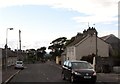
1
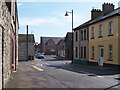
The top of Hill Street
Hill Street joins the A2 at this point.
Image: © Eric Jones
Taken: 20 Aug 2009
0.03 miles
2
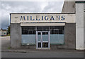
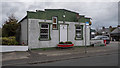
Vacant shop, Ardglass
The former Milligan's store on High Street, Ardglass - although I think it has moved to new premises nearby.
Image: © Rossographer
Taken: 23 Aug 2020
0.03 miles
3
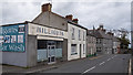
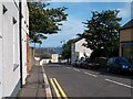
High Street, Ardglass
High Street in Ardglass.
Image: © Rossographer
Taken: 23 Aug 2020
0.04 miles
5
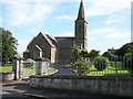
St Nicholas Church, Kildare Street, Ardglass
This is the parish church of the Church of Ireland's Ardglass Parish, It lies within the United Diocese of Down and Dromore, with sister cathedrals at Downpatrick and Dromore. (I'm grateful to Brian Shaw for drawing my attention the existence of the Dromore CofI Cathedral)
Image
Image
Image: © Eric Jones
Taken: 20 Aug 2009
0.04 miles
6
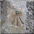
Bench Mark, Ardglass
Bench mark on the porch of the parish church in Ardglass Image This mark dates from the 1st geodetic levelling of Ireland which took place in 1839-43. It consists of a cut mark with a copper bolt driven into the wall of the church. The mark was included as a side level on the Dublin to Belfast line (branch levelling from Downpatrick to the tidal gauge in Ardglass Harbour - No. 14a)
The original remarks for the mark describe it as "Ardglass Church. Copper bolt driven into blockstone at door; 0.7 ft. above mark on sill of door."
The mark was originally levelled to 83.538 feet, later revised to 22.67 metres above MSL.
Image: © Rossographer
Taken: 24 Jul 2022
0.05 miles
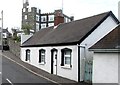
7
The Shield Hall, Ardglass
Old hall on High Street, Ardglass. It now appears to be part of a shop.
Image: © Rossographer
Taken: 23 Aug 2020
0.05 miles
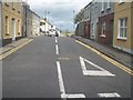
8
Kildare Street from the top of Hill Street
Image: © Eric Jones
Taken: 20 Aug 2009
0.05 miles
9
Houses near the Chapel in the High Street, Ardglass
Image: © Eric Jones
Taken: 22 Jul 2013
0.06 miles
10
Cottages below the King's Castle Private Nursing Home in Kildare Street. Ardglass
Image: © Eric Jones
Taken: 22 Jul 2013
0.06 miles