IMAGES TAKEN NEAR TO
Lighthouse Cove, DOWNPATRICK, BT30 7SU
Introduction
This page details the photographs taken nearby to Lighthouse Cove, BT30 7SU by members of the Geograph project.
The Geograph project started in 2005 with the aim of publishing, organising and preserving representative images for every square kilometre of Great Britain, Ireland and the Isle of Man.

There are currently over 7.5m images from over14,400 individuals and you can help contribute to the project by visiting https://www.geograph.org.uk
Image Map
Images are licensed for reuse under creativecommons.org/licenses/by-sa/2.0
Notes
- Clicking on the map will re-center to the selected point.
- The higher the marker number, the further away the image location is from the centre of the postcode.
Image Listing (62 Images Found)
Images are licensed for reuse under creativecommons.org/licenses/by-sa/2.0
Image
Details
Distance
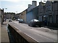
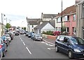
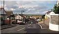
2
The junction of Strangford Road and Ardglass Road
Image: © Eric Jones
Taken: 22 Jul 2013
0.06 miles
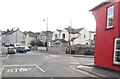
3
The junction of the B1 (Downpatrick Road) and the A2 (Strangford Road) at Ardglass
The image was taken from the bottom of Downpatrick Road.
Image: © Eric Jones
Taken: 23 Sep 2011
0.06 miles
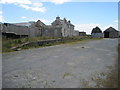
4
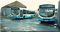
Ardglass bus depot (2)
The compound that now serves as Ardglass bus depot. The old garage Image is in the background.
Image: © Albert Bridge
Taken: 5 Dec 2009
0.08 miles
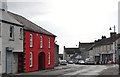
6
Strangford Road, Ardglass
This is part of the A2, Northern Ireland's Coastal Road which runs coastwise from Newry to Londonderry/Derry.
Image: © Eric Jones
Taken: 23 Sep 2011
0.08 miles
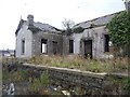
7
Ardglas railway station (site), County Down
Opened in 1892 as the terminus of the Belfast & County Down Railway's line from Downpatrick, this station closed in 1950.
View west from near the former buffers.
Image: © Nigel Thompson
Taken: 24 Jun 2017
0.08 miles
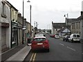
8
Quay Street, Ardglass
The image was taken from its junction with the A2 (Strangford Road).
Image: © Eric Jones
Taken: 22 Jul 2013
0.08 miles
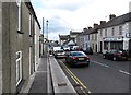
9
View north down Hill Street, Ardglass
Houses on the Ardglass Road can be seen in the valley bottom.
Image: © Eric Jones
Taken: 20 Aug 2009
0.08 miles
10
Ardglass
Ardglass opened in 1892 as the terminus of the Downpatrick, Killough & Ardglass Railway. It closed, along with the line in 1950 as part of the UTA's savage closure programme, leaving the County Down fishing village without a railway.
Image: © N-a
Taken: 14 Oct 2012
0.08 miles