IMAGES TAKEN NEAR TO
Killard Square, DOWNPATRICK, BT30 7PW
Introduction
This page details the photographs taken nearby to Killard Square, BT30 7PW by members of the Geograph project.
The Geograph project started in 2005 with the aim of publishing, organising and preserving representative images for every square kilometre of Great Britain, Ireland and the Isle of Man.

There are currently over 7.5m images from over14,400 individuals and you can help contribute to the project by visiting https://www.geograph.org.uk
Image Map
Images are licensed for reuse under creativecommons.org/licenses/by-sa/2.0
Notes
- Clicking on the map will re-center to the selected point.
- The higher the marker number, the further away the image location is from the centre of the postcode.
Image Listing (36 Images Found)
Images are licensed for reuse under creativecommons.org/licenses/by-sa/2.0
Image
Details
Distance
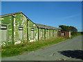
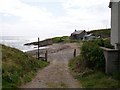
1
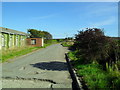
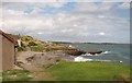
Killard Square, Ballyhornan
The entrance to Killard Square (a group of former military prefabs-cum-holiday chalets).
Image: © Dean Molyneaux
Taken: 13 Sep 2009
0.08 miles
2
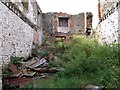
Ruined building on the coast south of Ballyhornan
Image: © Eric Jones
Taken: 20 Aug 2009
0.10 miles
3
View north towards the ruined building and sewage outlet pipe south of Ballyhornan
Image: © Eric Jones
Taken: 20 Aug 2009
0.11 miles
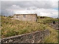
4
Derelict building at Ballyhornan
I'm not sure what this was, but it was likely something to do with the former RAF base at Bishopscourt.
Image: © Dean Molyneaux
Taken: 13 Sep 2009
0.11 miles
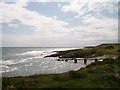
5
View north along the indented coastline from the southern end of Rock Road
Image: © Eric Jones
Taken: 20 Aug 2009
0.11 miles
6
Sewage discharge pipeline from the Ballyhornan sewage works
Image: © Eric Jones
Taken: 20 Aug 2009
0.11 miles
7
An old fisherman's cottage at the southern end of Rocks Road, Ballyhornan
This is the view northwards from the Ballyhornan Coastal Path.
Image: © Eric Jones
Taken: 20 Aug 2009
0.12 miles
8
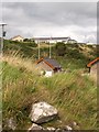
The Ballyhornan Pumping Station
Sewage from the station is pumped out to the sea, a pipeline being used to carry it to an outfall in deep water.
Image: © Eric Jones
Taken: 20 Aug 2009
0.13 miles
9
The untarred southern end of Rocks Road, Ballyhornan
Image: © Eric Jones
Taken: 20 Aug 2009
0.13 miles
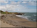
10
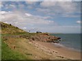
Sandy cove below Rocks Road
Killard Point at the entrance to Strangford Lough can be seen in the background.
Image: © Eric Jones
Taken: 20 Aug 2009
0.14 miles