IMAGES TAKEN NEAR TO
Killard Road, DOWNPATRICK, BT30 7PQ
Introduction
This page details the photographs taken nearby to Killard Road, BT30 7PQ by members of the Geograph project.
The Geograph project started in 2005 with the aim of publishing, organising and preserving representative images for every square kilometre of Great Britain, Ireland and the Isle of Man.

There are currently over 7.5m images from over14,400 individuals and you can help contribute to the project by visiting https://www.geograph.org.uk
Image Map
Images are licensed for reuse under creativecommons.org/licenses/by-sa/2.0
Notes
- Clicking on the map will re-center to the selected point.
- The higher the marker number, the further away the image location is from the centre of the postcode.
Image Listing (17 Images Found)
Images are licensed for reuse under creativecommons.org/licenses/by-sa/2.0
Image
Details
Distance
1
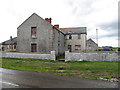
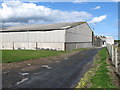
Derelict farmhouse on the Killard Road in Ballyhornan
Image: © Eric Jones
Taken: 22 Jul 2013
0.03 miles
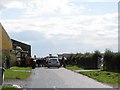
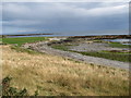
6
Eroding cliffs along the Killard Road
The barriers are intended to stop vehicles and pedestrians from entering the unstable cliff-top zone. The farmhouse on the left is another abandoned dwelling.
Image: © Eric Jones
Taken: 23 Sep 2011
0.09 miles
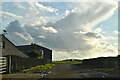
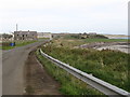
8
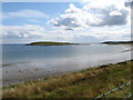
View south across the strand to Ballyhornan Bay and Guns Island
Some of the finest views of the island can be had from this point near the farm buildings on Killard Road.
Image: © Eric Jones
Taken: 22 Jul 2013
0.15 miles