IMAGES TAKEN NEAR TO
Ballyhosset Road, DOWNPATRICK, BT30 7ET
Introduction
This page details the photographs taken nearby to Ballyhosset Road, BT30 7ET by members of the Geograph project.
The Geograph project started in 2005 with the aim of publishing, organising and preserving representative images for every square kilometre of Great Britain, Ireland and the Isle of Man.

There are currently over 7.5m images from over14,400 individuals and you can help contribute to the project by visiting https://www.geograph.org.uk
Image Map
Images are licensed for reuse under creativecommons.org/licenses/by-sa/2.0
Notes
- Clicking on the map will re-center to the selected point.
- The higher the marker number, the further away the image location is from the centre of the postcode.
Image Listing (13 Images Found)
Images are licensed for reuse under creativecommons.org/licenses/by-sa/2.0
Image
Details
Distance
1
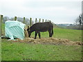
Donkey grazing at Tullynaskeagh
On a pasture alongside the Ballyhosset Road.
Townland of Tullynaskeagh.
Image: © Dean Molyneaux
Taken: 7 Feb 2010
0.02 miles
2
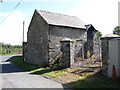
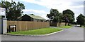
Converted former farm building at the junction of Ballyhosset and Tullynaskeagh roads
This is one of a group of farm buildings that have been converted into offices, sauna rooms and sun rooms.
Image]
Image: © Eric Jones
Taken: 18 Aug 2014
0.02 miles
3
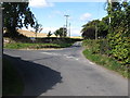
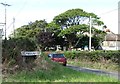
Ballyhosset Road at its junction with Tullynaskeagh Road
These are both minor roads providing access mainly to farms.
Image: © Eric Jones
Taken: 18 Aug 2014
0.03 miles
4
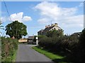
A large Edwardian former farmhouse at the junction of the Ballyhosset and Tullynaskeagh Roads
This house dates from 1907. Its outbuildings have been converted for domestic use.
Image]
Image: © Eric Jones
Taken: 18 Aug 2014
0.03 miles
5
The eastern end of Tullynaskeagh Road
The photo was taken from Ballyhosset Road.
Image: © Eric Jones
Taken: 18 Aug 2014
0.04 miles
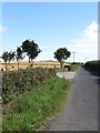
6
Holly Lane, Ballybranagh
This private lane is off the Ballyhosset Road.
Image: © Eric Jones
Taken: 18 Aug 2014
0.05 miles
7
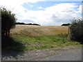
Grain crop on the lee slope of a drumlin at the Chambers Farm,Tullynaskeagh
Image: © Eric Jones
Taken: 18 Aug 2014
0.08 miles
8
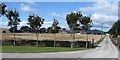
Farmhouse and buildings at Chambers Farm, Tullynaskeagh
This is one of the best arable farms in Northern Ireland. A three year rotation is practised. with winter wheat in year one, followed by winter barley, followed by, in year three, maize or potatoes.
Image: © Eric Jones
Taken: 18 Aug 2014
0.09 miles
9
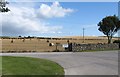
Baled straw at Chambers Farm, Tullynaskeagh
Image: © Eric Jones
Taken: 18 Aug 2014
0.13 miles
10
View east along Ballyhosset Road
The entrance on the left leads to the farm yard of Chambers Farm.
Image: © Eric Jones
Taken: 18 Aug 2014
0.15 miles