IMAGES TAKEN NEAR TO
Demesne Hollow, DOWNPATRICK, BT30 6WF
Introduction
This page details the photographs taken nearby to Demesne Hollow, BT30 6WF by members of the Geograph project.
The Geograph project started in 2005 with the aim of publishing, organising and preserving representative images for every square kilometre of Great Britain, Ireland and the Isle of Man.

There are currently over 7.5m images from over14,400 individuals and you can help contribute to the project by visiting https://www.geograph.org.uk
Image Map
Images are licensed for reuse under creativecommons.org/licenses/by-sa/2.0
Notes
- Clicking on the map will re-center to the selected point.
- The higher the marker number, the further away the image location is from the centre of the postcode.
Image Listing (21 Images Found)
Images are licensed for reuse under creativecommons.org/licenses/by-sa/2.0
Image
Details
Distance
1
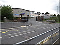
St Mary's High School, Ardglass Road, Downpatrick
This is a Catholic ethos community state school. It was established by the Sisters of Mercy as St Mary's Girls' Intermediate School in 1957 and in 1960 a grammar stream was added. Its name was then changed to St Mary's High School.
Image: © Eric Jones
Taken: 21 Mar 2018
0.10 miles
2
St Mary's High School, Ardglass Road
This is a Catholic ethos community state school. It was established by the Sisters of Mercy as St Mary's Girls' Intermediate School in 1957 and in 1960 a grammar stream was added. Its name was then changed to St Mary's High School.
Image: © Eric Jones
Taken: 18 Aug 2014
0.11 miles
3
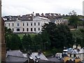
The now disused Downpatrick Hospital from St Patrick's Church
Image: © Eric Jones
Taken: 20 Aug 2009
0.14 miles
4
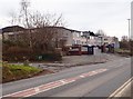
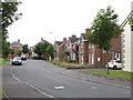
Houses at the junction of Ardglass Road and Edward Street, Downpatrick
Image: © Eric Jones
Taken: 18 Aug 2014
0.14 miles
6
The derelict "old" Downe Hospital
The old infirmary was more accessible from the town than the new one which is located on the urban fringe.
Image: © Eric Jones
Taken: 21 Mar 2018
0.16 miles
8
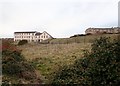
Surviving wing of the largely demolished former Downe Hospital at Downpatrick
Image: © Eric Jones
Taken: 23 Jan 2020
0.19 miles
9
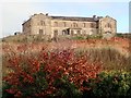
Housing under construction on the site of the Old Downe Hospital, Downpatrick
This is the delayed Phase I of the construction of Social Housing on the Old Downe Hospital site, consisting of houses and bungalows. The most historic sections of the infirmary have been retained, for later conversion into apartments. The image was taken on the Killough Road as it approaches the B1 (Ardglass Road) junction.
Image: © Eric Jones
Taken: 1 Oct 2020
0.20 miles
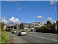
10

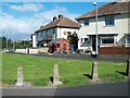
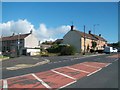
Ardglass Road from its junction with Killough Road
Image: © Eric Jones
Taken: 20 Jul 2011
0.21 miles