IMAGES TAKEN NEAR TO
Kincora Drive, DOWNPATRICK, BT30 6HW
Introduction
This page details the photographs taken nearby to Kincora Drive, BT30 6HW by members of the Geograph project.
The Geograph project started in 2005 with the aim of publishing, organising and preserving representative images for every square kilometre of Great Britain, Ireland and the Isle of Man.

There are currently over 7.5m images from over14,400 individuals and you can help contribute to the project by visiting https://www.geograph.org.uk
Image Map
Images are licensed for reuse under creativecommons.org/licenses/by-sa/2.0
Notes
- Clicking on the map will re-center to the selected point.
- The higher the marker number, the further away the image location is from the centre of the postcode.
Image Listing (19 Images Found)
Images are licensed for reuse under creativecommons.org/licenses/by-sa/2.0
Image
Details
Distance
1
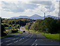
View South West along Flying Horse Road, Downpatrick
This urban fringe road affords an excellent view of the High Mournes. Slieve Donard, Ulster's highest mountain, is the pyramidical peak in the centre.
Image: © Eric Jones
Taken: 1 Oct 2020
0.15 miles
3
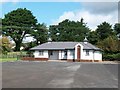
Amenity Building and Toilets at Struell Cemetery
Image: © Eric Jones
Taken: 20 Aug 2009
0.20 miles
4
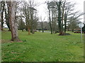
Parkland at the Downshire Estate, Downpatrick
Image: © Eric Jones
Taken: 21 Mar 2018
0.20 miles
5
Wee girl with bunches of flowers at the back entrance to the Downe Hospital
This piece of public art by Michael Disley is entitled "Full Bloom".
Image: © Eric Jones
Taken: 1 Oct 2020
0.22 miles
6
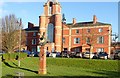
Memorial for the Patients and Staff of the former Downshire Mental Hospital
This is located in front of the hospital's Great Hall.
The grand buildings on the Downshire Estate had for almost a century housed one of the biggest mental institutions in Northern Ireland. The Downshire Mental Hospital was for decades the biggest employer in Downpatrick. The abolition of large mental asylum in the second half of the 20thC saw the closure of the Downshire Mental Hospital
Image: © Eric Jones
Taken: 23 Jan 2020
0.22 miles
7
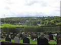
Struell Cemetery, Old Course Road, Downpatrick
This is a municipal cemetery. off Flying Horse Road. The Mourne Mountains can be seen in the background.
Image: © Eric Jones
Taken: 20 Aug 2009
0.22 miles
8
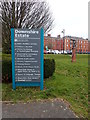
South Eastern Health and Social Care Trust direction board on the Downshire Estate
This provides a list of the various SEH&SCT services housed on the Downshire Estate site.
Image: © Eric Jones
Taken: 21 Mar 2018
0.23 miles
9
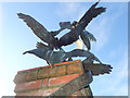
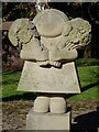
Bird statue on the site of the former Downshire Mental Hospital
This commemorates the former patients and staff of the hospital.
Image: © Eric Jones
Taken: 23 Jan 2020
0.23 miles
10
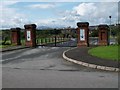
Gates to the Pairc Tomas Ruseil GAA Club, Dun Phadraig
The club is named after the executed United Irishmen leader, Thomas Russell, who is buried at Downpatrick's St Margaret CofI Parish Church.
http://www.irishnews.com/gaaworld/ulster/down/Downpatrick/index.html
Image: © Eric Jones
Taken: 20 Aug 2009
0.23 miles