IMAGES TAKEN NEAR TO
Church View, DOWNPATRICK, BT30 6GB
Introduction
This page details the photographs taken nearby to Church View, BT30 6GB by members of the Geograph project.
The Geograph project started in 2005 with the aim of publishing, organising and preserving representative images for every square kilometre of Great Britain, Ireland and the Isle of Man.

There are currently over 7.5m images from over14,400 individuals and you can help contribute to the project by visiting https://www.geograph.org.uk
Image Map
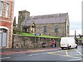
Images are licensed for reuse under creativecommons.org/licenses/by-sa/2.0
Notes
- Clicking on the map will re-center to the selected point.
- The higher the marker number, the further away the image location is from the centre of the postcode.
Image Listing (219 Images Found)
Images are licensed for reuse under creativecommons.org/licenses/by-sa/2.0
Image
Details
Distance
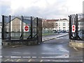
1
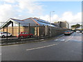
Traffic calming measure by the Down High School in Bridge Street
The wall surrounding the school dates from the time when the site was part of the Down County Gaol.
Image: © Eric Jones
Taken: 4 Mar 2014
0.01 miles
2
The main entrance to St Margaret's CofI Church, Downpatrick
St Margaret's was first erected in 1560, with the present building being built in 1735. It is the Anglican parish church of Downpatrick.
Image: © Eric Jones
Taken: 20 Aug 2009
0.03 miles
3
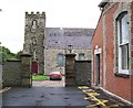
Down High School - a school within former prison walls
The school has been built on part of what used to be the Down County Jail. The prison walls and the gatehouse remain.
Image: © Eric Jones
Taken: 4 Mar 2014
0.03 miles
4
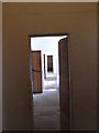
Cell block corridor at the former Downpatrick Gaol
Image: © Eric Jones
Taken: 7 Jun 2011
0.04 miles
5
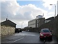
Traffic exit from the Down High School, Downpatrick
Image: © Eric Jones
Taken: 4 Mar 2014
0.04 miles
6
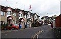
Bridge Street - a Loyalist enclave near St Margaret's Church
Downpatrick is a predominantly Nationalist city with 87% of the population from a Catholic Community background and 12% of a 'Protestant and Other Christian (including Christian related)' Community Background.
Image: © Eric Jones
Taken: 20 Aug 2009
0.05 miles
7
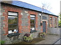
Union Chapel/ Prayer Meeting House in Bridge Street
This evangelical meeting house was erected in 1861. It is also known as Pilson Hall after the radical diarist Aynsworth Pilson, who was the proprietor of the Downpatrick Recorder. The building is still in use.
Image: © Eric Jones
Taken: 4 Mar 2014
0.05 miles
8
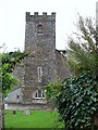
The tower of St Margaret CofI Parish Church
Image: © Eric Jones
Taken: 20 Aug 2009
0.05 miles
9
St Margaret's CofI Parish Church from Church Street
Thomas Russell the co-founder of the United Irishmen is buried here. A former officer in the 64th of Foot, he was inspired by the ideals of the French Revolution and sought the co-operation of Ireland's Roman Catholics and Protestant Dissenters in an uprising against the Establishment. For his troubles he was hung at the main gate of Downpatrick Gaol on 21 October 1803 and then beheaded. The prison gate is shown in the following photo
Image]
http://www.devlin-family.com/Russell.htm
Image: © Eric Jones
Taken: 20 Aug 2009
0.05 miles
10
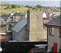
St Margaret's Anglican Church from the Protestant Bridge Street Estate
The Bridge Street/Mount Crescent area is the only Protestant/Unionist
housing area in an otherwise predominantly Catholic/Nationalist Downpatrick.
Image: © Eric Jones
Taken: 4 Mar 2014
0.06 miles