IMAGES TAKEN NEAR TO
Cidercourt Road, CRUMLIN, BT29 4RX
Introduction
This page details the photographs taken nearby to Cidercourt Road, BT29 4RX by members of the Geograph project.
The Geograph project started in 2005 with the aim of publishing, organising and preserving representative images for every square kilometre of Great Britain, Ireland and the Isle of Man.

There are currently over 7.5m images from over14,400 individuals and you can help contribute to the project by visiting https://www.geograph.org.uk
Image Map
Images are licensed for reuse under creativecommons.org/licenses/by-sa/2.0
Notes
- Clicking on the map will re-center to the selected point.
- The higher the marker number, the further away the image location is from the centre of the postcode.
Image Listing (3 Images Found)
Images are licensed for reuse under creativecommons.org/licenses/by-sa/2.0
Image
Details
Distance
2
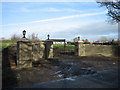
New Gates
It appears that these gates will be operated by remote control.
Image: © Brian Shaw
Taken: 8 Dec 2005
0.08 miles
3
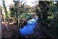
Crumlin River
The Crumlin River reflects a blue winter sky as it passes under Cidercourt Road on its way to Lough Neagh, about a mile away. Taken from Cidercourt Bridge close to Crumlin.
Image: © Robert Ashby
Taken: 4 Dec 2013
0.12 miles