IMAGES TAKEN NEAR TO
Berkley Manor, CRUMLIN, BT29 4DP
Introduction
This page details the photographs taken nearby to Berkley Manor, BT29 4DP by members of the Geograph project.
The Geograph project started in 2005 with the aim of publishing, organising and preserving representative images for every square kilometre of Great Britain, Ireland and the Isle of Man.

There are currently over 7.5m images from over14,400 individuals and you can help contribute to the project by visiting https://www.geograph.org.uk
Image Map
Images are licensed for reuse under creativecommons.org/licenses/by-sa/2.0
Notes
- Clicking on the map will re-center to the selected point.
- The higher the marker number, the further away the image location is from the centre of the postcode.
Image Listing (85 Images Found)
Images are licensed for reuse under creativecommons.org/licenses/by-sa/2.0
Image
Details
Distance
1
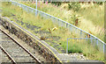
Platform, Crumlin station (August 2014)
The Lisburn end of the disused up platform - looking a bit more overgrown than in June 2012 Image
Image: © Albert Bridge
Taken: 16 Aug 2014
0.07 miles
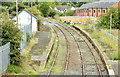
2
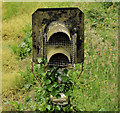
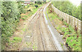
Signal, Crumlin station
A disused and ivy-covered signal, at the Lisburn/Belfast end of the loop Image on the “mothballed” line, at Crumlin Image When needed the line is worked as one section. When open it had three sections: Lisburn – Ballinderry, Ballinderry – Crumlin and Crumlin – Antrim. For comparison see Image after remedial work to retain the line in a safe running order.
Image: © Albert Bridge
Taken: 17 Jun 2012
0.07 miles
3
Railway, Crumlin (1)
The “mothballed” Lisburn – Antrim line on the Lisburn/Belfast side of Crumlin station Image For comparison see Image after remedial work to retain the line in a safe running order.
Image: © Albert Bridge
Taken: 17 Jun 2012
0.07 miles
4
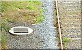
New drain, Crumlin station (August 2014)
The contract includes improvements to the line’s drainage. This new drain is beside the through/fast line at the Lisburn end of the down platform.
Image: © Albert Bridge
Taken: 16 Aug 2014
0.07 miles
5
Crumlin station - August 2014(2)
See Image (June 2012). Changes, on the Lisburn side of the former loop, include the clearance of weeds and lineside vegetation, some new ballast, a new drain and the removal of the old and disused signals Image
Image: © Albert Bridge
Taken: 16 Aug 2014
0.07 miles
6
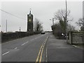
Main Street, Crumlin
Heading east out of town; my attention was drawn to the stone clock tower on the left - see Image]
Image: © Kenneth Allen
Taken: 26 Jan 2010
0.08 miles
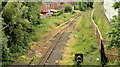
7
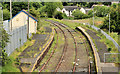
Crumlin station (2012)
The “mothballed” Crumlin station, looking towards Antrim, from the overbridge at the eastern end of Main Street. Now a bit forlorn and in need of spraying to keep the weeds under control. This one shows the station in June 1974, not long after it had re-opened to passenger trains Image For comparison see Image after remedial work to retain the line in a safe running order.
Image: © Albert Bridge
Taken: 17 Jun 2012
0.08 miles
8
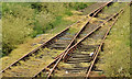
Railway, Crumlin (2)
The Lisburn/Belfast end of the passing loop at Crumlin station Image
Image: © Albert Bridge
Taken: 17 Jun 2012
0.08 miles
9
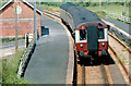
Crumlin station (1974)
A three-car MPD set at Crumlin with the 14.05 Crumlin – Lisburn, not long after the passenger service had been restored. The track was still pristine. See also Image
Image: © Albert Bridge
Taken: 22 Jun 1974
0.09 miles
10
Crumlin station - August 2014(1)
See Image June 2012. The former loop (right) is now free from weeds though some remain on the through/fast line. The platforms have not been treated. There is some new ballast at the Antrim end of the station. On a non-railway note there are now new houses, backing onto the railway, at top right. See also Image (June 1974).
Image: © Albert Bridge
Taken: 16 Aug 2014
0.09 miles