IMAGES TAKEN NEAR TO
Killultagh Road, LISBURN, BT28 2PS
Introduction
This page details the photographs taken nearby to Killultagh Road, BT28 2PS by members of the Geograph project.
The Geograph project started in 2005 with the aim of publishing, organising and preserving representative images for every square kilometre of Great Britain, Ireland and the Isle of Man.

There are currently over 7.5m images from over14,400 individuals and you can help contribute to the project by visiting https://www.geograph.org.uk
Image Map
Images are licensed for reuse under creativecommons.org/licenses/by-sa/2.0
Notes
- Clicking on the map will re-center to the selected point.
- The higher the marker number, the further away the image location is from the centre of the postcode.
Image Listing (4 Images Found)
Images are licensed for reuse under creativecommons.org/licenses/by-sa/2.0
Image
Details
Distance
2
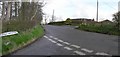
The Killultagh Road near Stoneyford (May 2017)
A rural road running south east from the Crewe Road Image
Image: © Albert Bridge
Taken: 20 May 2017
0.19 miles
3
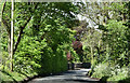
Filterbeds Road
It is located at Derrykillultagh
Image: © Kenneth Allen
Taken: 9 Apr 2008
0.22 miles
4
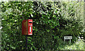
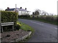
Postbox BT28 92, Derrykillultagh near Stoneyford (May 2017)
Post-mounted EIIR postbox (BT28 92), on the Crewe Road Image, at Killintagh Crossroads.
Image: © Albert Bridge
Taken: 20 May 2017
0.23 miles