IMAGES TAKEN NEAR TO
Corrstown Road, LISBURN, BT28 2NH
Introduction
This page details the photographs taken nearby to Corrstown Road, BT28 2NH by members of the Geograph project.
The Geograph project started in 2005 with the aim of publishing, organising and preserving representative images for every square kilometre of Great Britain, Ireland and the Isle of Man.

There are currently over 7.5m images from over14,400 individuals and you can help contribute to the project by visiting https://www.geograph.org.uk
Image Map
Images are licensed for reuse under creativecommons.org/licenses/by-sa/2.0
Notes
- Clicking on the map will re-center to the selected point.
- The higher the marker number, the further away the image location is from the centre of the postcode.
Image Listing (4 Images Found)
Images are licensed for reuse under creativecommons.org/licenses/by-sa/2.0
Image
Details
Distance
1
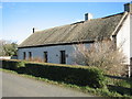
Thatched Cottage
On Old Road in the townland of Loughrelisk.
Image: © Brian Shaw
Taken: 20 Feb 2006
0.09 miles
2
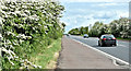
The Moira Road, Ballylacky, Moira/Ballinderry (May 2017)
See Image The same road, further north. Almost 40 years ago I used to pass here quite frequently. My thoughts were not so much on the traffic (almost none then) but whether the landscaping would ever grow!
Image: © Albert Bridge
Taken: 20 May 2017
0.18 miles
3
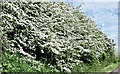
Spring blossom, Ballylacky, Moira/Ballinderry (May 2017)
An abundance of blossom by the side of this stretch of the Moira Road Image
Image: © Albert Bridge
Taken: 20 May 2017
0.19 miles
4
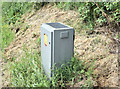
Traffic counter, Ballylacky, Moira/Ballinderry (May 2017)
A solar-powered traffic counter beside the Moira Road Image
Image: © Albert Bridge
Taken: 20 May 2017
0.20 miles