IMAGES TAKEN NEAR TO
Divis Way, LISBURN, BT28 1DP
Introduction
This page details the photographs taken nearby to Divis Way, BT28 1DP by members of the Geograph project.
The Geograph project started in 2005 with the aim of publishing, organising and preserving representative images for every square kilometre of Great Britain, Ireland and the Isle of Man.

There are currently over 7.5m images from over14,400 individuals and you can help contribute to the project by visiting https://www.geograph.org.uk
Image Map
Images are licensed for reuse under creativecommons.org/licenses/by-sa/2.0
Notes
- Clicking on the map will re-center to the selected point.
- The higher the marker number, the further away the image location is from the centre of the postcode.
Image Listing (41 Images Found)
Images are licensed for reuse under creativecommons.org/licenses/by-sa/2.0
Image
Details
Distance
1
Benson Street, Lisburn (2)
See Image Before the opening of the Thiepval Road Image, Benson Street was a through street from the Antrim Road to the Causeway End Road. The new road cut it leaving a short stub (behind me) at the Antrim Road end. This is the view from the Thiepval Road to the Causeway End Road. The connection from this part of the street to the Antrim Road is by the Bentrim Road (bottom right).
Image: © Albert Bridge
Taken: 19 Oct 2010
0.13 miles
2
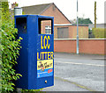
Doggy bin, Lisburn
A bin, for dog dirt, at the Benson Street end of Mountainvale Park. “LCC” is Lisburn City Council and not the long-departed London County Council. The street is shown but not named on the Google map.
Image: © Albert Bridge
Taken: 2 Dec 2012
0.15 miles
3
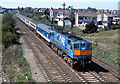
Train approaching Lisburn station - 1989
Northern Ireland Railways GM built 113 brings the 10.30 passenger service from Dublin (Connolly) to Belfast (Central) towards Lisburn station. Note the second coach, a former British Rail MkII FO, which NIR had recently purchased from BR and was still in BR colours.
Image: © The Carlisle Kid
Taken: 7 May 1989
0.15 miles
4
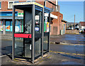
Telephone boxes, Lisburn (2013-1)
Two telephone boxes outside the shops at the corner of Longstone Street and Tonagh Drive.
Image: © Albert Bridge
Taken: 14 Apr 2013
0.17 miles
5
Benson Street, Lisburn (1)
Before the opening of the Thiepval Road Image, Benson Street was a through street from the Antrim Road to the Causeway End Road. The new road cut it leaving a short stub (behind me) at the Antrim Road end. This is the view from the Thiepval Road to the Causeway End Road. The connection from this part of the street to the Antrim Road is by the Bentrim Road (upper right, at the warehouse). See also Image
Image: © Albert Bridge
Taken: 19 Oct 2010
0.18 miles
6
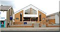
Lisburn Baptist Church
The present church, in Longstone Street, opened in 1977 replacing one in nearby Tonagh Avenue.
Image: © Albert Bridge
Taken: 6 Aug 2009
0.18 miles
7
Former Ulster Bank, Longstone Street, Lisburn (May 2014)
See Image (April 2013). The premises (middle) remain vacant.
Image: © Albert Bridge
Taken: 18 May 2014
0.18 miles
8
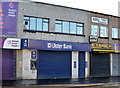
The Ulster Bank (Longstone Street branch), Lisburn
See Image The Longstone branch of the Ulster Bank (near the corner of Warren Gardens) is due to close on 7 June 2013 with accounts transferred to Bow Street. Continue to Image See also Image
Image: © Albert Bridge
Taken: 14 Apr 2013
0.18 miles
9
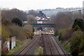
Thiepval Rd Bridge
Thiepval Rd Bridge photographed from the Causeway End Rd. It is not possible to get closer for a better photograph without trespassing on the railway.
the platforms of Lisburn Railway Station can be viewed beyond the bridge.
Image: © Wilson Adams
Taken: 13 Apr 2008
0.18 miles
10
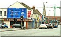
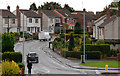
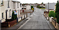
Longstone Street, Lisburn
Longstone Street (commonly “The Longstone”) is the continuation of the Moira Road into the centre of Lisburn. It has managed to retain a variety of shops to serve local residents (the Tonagh and Old Warren estates are nearby).
Image: © Albert Bridge
Taken: 11 Jan 2009
0.19 miles