IMAGES TAKEN NEAR TO
Brookvale Rise, LISBURN, BT28 1DE
Introduction
This page details the photographs taken nearby to Brookvale Rise, BT28 1DE by members of the Geograph project.
The Geograph project started in 2005 with the aim of publishing, organising and preserving representative images for every square kilometre of Great Britain, Ireland and the Isle of Man.

There are currently over 7.5m images from over14,400 individuals and you can help contribute to the project by visiting https://www.geograph.org.uk
Image Map
Images are licensed for reuse under creativecommons.org/licenses/by-sa/2.0
Notes
- Clicking on the map will re-center to the selected point.
- The higher the marker number, the further away the image location is from the centre of the postcode.
Image Listing (85 Images Found)
Images are licensed for reuse under creativecommons.org/licenses/by-sa/2.0
Image
Details
Distance
1
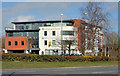
Garvey Studios, Lisburn
Now a prominent landmark in Lisburn, Garvey Studios is an office building at the corner of Longstone Street and the Thiepval Road. This view is from the Governor’s Road.
Image: © Albert Bridge
Taken: 14 Apr 2013
0.07 miles
2
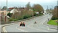
The Thiepval Road, Lisburn (2)
See Image The view towards Chapel Hill and the Longstone. Ridgeway Street is at bottom right.
Image: © Albert Bridge
Taken: 11 Jan 2009
0.10 miles
3
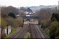
Thiepval Rd Bridge
Thiepval Rd Bridge photographed from the Causeway End Rd. It is not possible to get closer for a better photograph without trespassing on the railway.
the platforms of Lisburn Railway Station can be viewed beyond the bridge.
Image: © Wilson Adams
Taken: 13 Apr 2008
0.11 miles
4
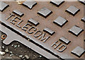
Telecom HD access cover, Lisburn (2)
See Image The inscription.
Image: © Albert Bridge
Taken: 19 May 2013
0.11 miles
5
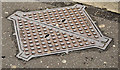
Telecom HD access cover, Lisburn (1)
An access cover, at Chapel Hill, marked “Telecom HD” which (I think) is explained by this link http://en.wikipedia.org/wiki/HDSL. Image shows the inscription.
Image: © Albert Bridge
Taken: 19 May 2013
0.11 miles
6
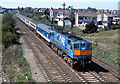
Train approaching Lisburn station - 1989
Northern Ireland Railways GM built 113 brings the 10.30 passenger service from Dublin (Connolly) to Belfast (Central) towards Lisburn station. Note the second coach, a former British Rail MkII FO, which NIR had recently purchased from BR and was still in BR colours.
Image: © The Carlisle Kid
Taken: 7 May 1989
0.11 miles
7
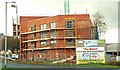
The "Manor", Lisburn
New apartments under construction at the bottom of the Longstone.
Image: © Albert Bridge
Taken: 5 Jan 2009
0.11 miles
8
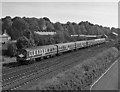
Special train leaving Lisburn
Headed by No. 99 "Sir Myles Humphreys", a 6-car 80-class set pulls away from Lisburn with a "Sunday School" excursion to Portrush.
Martin Baumann advises the set numbers as: 99-773-749-751-778-83
Image: © The Carlisle Kid
Taken: 11 Jun 1988
0.12 miles
9
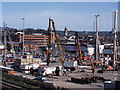
Construction work - Bow Street mall
Work begins on building an extension to the Bow Street shopping mall.
Image: © The Carlisle Kid
Taken: 26 Mar 2002
0.12 miles
10
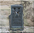
Flush Bracket, Lisburn
Flush bracket located on the north-eastern side of St Patrick's RC Church, Chapel Hill, Lisburn Image
The number on the bracket is OSNIBM 3096.
The mark is 43.98 metres above MSL.
A flush bracket is a type of bench mark set onto the face of a building. See also http://www.geograph.org.uk/search.php?i=11037856 for many other examples I have found.
Image: © Rossographer
Taken: 25 Aug 2010
0.13 miles