IMAGES TAKEN NEAR TO
Bow Street Mall, Bow Street, LISBURN, BT28 1AW
Introduction
This page details the photographs taken nearby to Bow Street Mall, Bow Street, BT28 1AW by members of the Geograph project.
The Geograph project started in 2005 with the aim of publishing, organising and preserving representative images for every square kilometre of Great Britain, Ireland and the Isle of Man.

There are currently over 7.5m images from over14,400 individuals and you can help contribute to the project by visiting https://www.geograph.org.uk
Image Map
Images are licensed for reuse under creativecommons.org/licenses/by-sa/2.0
Notes
- Clicking on the map will re-center to the selected point.
- The higher the marker number, the further away the image location is from the centre of the postcode.
Image Listing (211 Images Found)
Images are licensed for reuse under creativecommons.org/licenses/by-sa/2.0
Image
Details
Distance
1
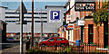
Multi-storey car park, Lisburn
1,000 spaces for the Bow Street Mall now stand on the site of Barbour Threads Image The view is along Bachelor’s Walk.
Image: © Albert Bridge
Taken: 12 Sep 2010
0.05 miles
2
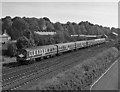
Special train leaving Lisburn
Headed by No. 99 "Sir Myles Humphreys", a 6-car 80-class set pulls away from Lisburn with a "Sunday School" excursion to Portrush.
Martin Baumann advises the set numbers as: 99-773-749-751-778-83
Image: © The Carlisle Kid
Taken: 11 Jun 1988
0.05 miles
3
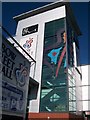
The tower of the Bow Street Mall, Lisburn
This tower houses the stairs that gives access to the different floors of BHS.
Image: © Eric Jones
Taken: 12 Oct 2012
0.08 miles
4
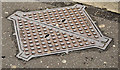
Telecom HD access cover, Lisburn (1)
An access cover, at Chapel Hill, marked “Telecom HD” which (I think) is explained by this link http://en.wikipedia.org/wiki/HDSL. Image shows the inscription.
Image: © Albert Bridge
Taken: 19 May 2013
0.08 miles
5
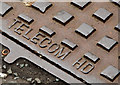
Telecom HD access cover, Lisburn (2)
See Image The inscription.
Image: © Albert Bridge
Taken: 19 May 2013
0.08 miles
6
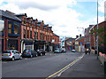
Chapel Hill, Lisburn
Street in Lisburn leading from St Patrick's RC church into the city centre.
Image: © Rossographer
Taken: 25 Aug 2010
0.09 miles
7
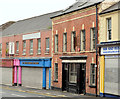
"Laverys", Lisburn (1)
A locally well-known bar at Chapel Hill. Listed http://www.doeni.gov.uk/niea/built/buildview?id=16054&js=true where the description includes “A mid-terrace two-storey-with-attic, three-bay former house built c.1800 and remodelled c.1870 into a public house”. Image shows the remodelling.
Image: © Albert Bridge
Taken: 19 May 2013
0.09 miles
8
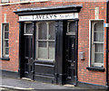
"Laverys", Lisburn (2)
See Image A closer look (from slightly further down the hill) at the remodelling mentioned in the link. For a similar facade see Image
Image: © Albert Bridge
Taken: 19 May 2013
0.09 miles
9
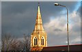
Spire, St Patrick's, Lisburn
The spire of St Patrick’s (RC) church at Chapel Hill and the spire of Lisburn (CoI) Cathedral Image are dominant features particularly when seen heading south on the M1. The church was dedicated in June 1900 but the tower had to wait until 1932 before completion in its present form. The following additional information has been kindly supplied by a visitor to the site: the spire was designed by Gerard I O’Gorman in 1932, a parishioner who lived nearby. He was commissioned by Canon O' Boyle, the parish priest at the time.
Image: © Albert Bridge
Taken: 5 Jan 2009
0.09 miles
10
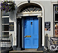
Doorway, Lisburn (3)
The doorway of no 68 Bow Street. Originally a house built circa 1850 and later converted for commercial use. See this link http://www.doeni.gov.uk/niea/built/buildview?id=1476&js=true for a more detailed description.
Image: © Albert Bridge
Taken: 23 Sep 2012
0.09 miles