IMAGES TAKEN NEAR TO
Carryduff Road, LISBURN, BT27 6YL
Introduction
This page details the photographs taken nearby to Carryduff Road, BT27 6YL by members of the Geograph project.
The Geograph project started in 2005 with the aim of publishing, organising and preserving representative images for every square kilometre of Great Britain, Ireland and the Isle of Man.

There are currently over 7.5m images from over14,400 individuals and you can help contribute to the project by visiting https://www.geograph.org.uk
Image Map
Images are licensed for reuse under creativecommons.org/licenses/by-sa/2.0
Notes
- Clicking on the map will re-center to the selected point.
- The higher the marker number, the further away the image location is from the centre of the postcode.
Image Listing (15 Images Found)
Images are licensed for reuse under creativecommons.org/licenses/by-sa/2.0
Image
Details
Distance
1
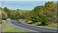
The Carryduff Road near The Temple Crossroads (October 2015)
See Image (May 2010) and Image A sweep in the Belfast – Newcastle road north of The Temple Crossroads. Sweeps are a feature of the road as it passes through the drumlin country between Carryduff and Clough.
Image: © Albert Bridge
Taken: 17 Oct 2015
0.01 miles
2
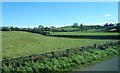
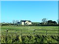
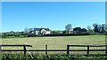
Farmland on the eastern side of the A24
This tract of drumlinised drift is located just north of the Temple Crossroads
Image: © Eric Jones
Taken: 15 Oct 2018
0.05 miles
3
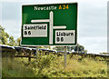
Direction sign, The Temple Crossroads (October 2015)
Direction sign approaching the crossroads from the Carryduff/Belfast direction.
Image: © Albert Bridge
Taken: 17 Oct 2015
0.06 miles
4
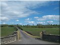
Private farm road leading eastwards from the A24
Image: © Eric Jones
Taken: 27 Apr 2012
0.08 miles
5
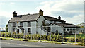
Derelict house, The Temple near Carryduff (October 2015)
A derelict house and outbuildings, on the western side of the Carryduff Road, to the north of the crossroads. I can’t find any reference to an existing planning permission.
Image: © Albert Bridge
Taken: 17 Oct 2015
0.11 miles
6
Detached house off the A24 at Temple
The crane and buildings to its right are at the BDS Training Centre.
Image: © Eric Jones
Taken: 7 Dec 2018
0.12 miles
7
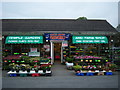
Fireworks for sale at Temple Garden and Farm Shop
Temple Garden and Farm Shop at Temple roundabout well stocked with Fireworks and Wild bird food and a show of plants outside
Image: © Hugh Gilmore
Taken: 16 Oct 2009
0.15 miles
8
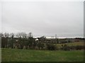
Farmland and scattered rural settlement in The Temple area
Image: © Eric Jones
Taken: 15 Feb 2012
0.16 miles
9
Large detached house north of The Temple Crossroads
The image taken from the A24 also shows a crane which is located at the adjacent BSD Building Skills Training Centre.
Image: © Eric Jones
Taken: 15 Oct 2018
0.19 miles
10
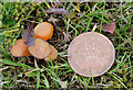
Fungi, The Temple near Carryduff (October 2015)
A tiny fungus, growing on a well-mown and wide verge, north of the crossroads.
Image: © Albert Bridge
Taken: 17 Oct 2015
0.22 miles