IMAGES TAKEN NEAR TO
Ballyskeagh Road, LISBURN, BT27 5TD
Introduction
This page details the photographs taken nearby to Ballyskeagh Road, BT27 5TD by members of the Geograph project.
The Geograph project started in 2005 with the aim of publishing, organising and preserving representative images for every square kilometre of Great Britain, Ireland and the Isle of Man.

There are currently over 7.5m images from over14,400 individuals and you can help contribute to the project by visiting https://www.geograph.org.uk
Image Map
Images are licensed for reuse under creativecommons.org/licenses/by-sa/2.0
Notes
- Clicking on the map will re-center to the selected point.
- The higher the marker number, the further away the image location is from the centre of the postcode.
Image Listing (36 Images Found)
Images are licensed for reuse under creativecommons.org/licenses/by-sa/2.0
Image
Details
Distance
1
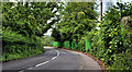
The Ballyskeagh Road, Lambeg
The Ballyskeagh Road, passing the Lambeg Mills, on the approach to Lambeg via Wolfenden’s Bridge Image
Image: © Albert Bridge
Taken: 18 Jun 2011
0.03 miles
2
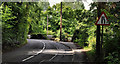
Church Hill, Lambeg
A twisting tree-lined continuation of the Ballyskeagh Road as it approaches Lambeg. The “road narrows on the right” sign is a reference to Wolfenden’s Bridge Image
Image: © Albert Bridge
Taken: 18 Jun 2011
0.14 miles
3

The Ballyskeagh Road near Dunmurry (4)
Image showed the Ballyskeagh Road approaching the High Bridge from the Drumbeg side. This is the approach from the Lambeg side. The bridge is hidden to the left.
Image: © Albert Bridge
Taken: 21 Aug 2010
0.17 miles
4

The High Bridge, Ballyskeagh
A view looking towards Lisburn from No.8 Lock.
Image: © Wilson Adams
Taken: Unknown
0.18 miles
5
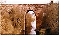
The High Bridge, Ballyskeagh
A view of the High Bridge, Ballyskeagh looking towards No.8 Lock.
Image: © Wilson Adams
Taken: Unknown
0.18 miles
6
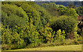
Trees, Ballyskeagh (1)
A line of trees, seen from near the Ballyskeagh Road, marking the course of the towpath and disused Lagan canal as they pass McIlroy Park.
Image: © Albert Bridge
Taken: 18 Jun 2011
0.18 miles
7
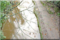
The Lagan towpath, Ballyskeagh (November 2014)
Given the state of the towpath Image at Drumbeg I expected something similar at the High Bridge but, as you can see, it was completely clear. The canal, however, was full and muddy. This view is from the footbridge Image looking towards Drumbeg and Belfast. This view (allowing for summer vegetation) Image (June 2011) shows the canal at a lower level.
Image: © Albert Bridge
Taken: 15 Nov 2014
0.18 miles
8
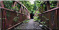
Footbridge, Ballyskeagh
See Image Ten months later. The surrounding vegetation is doing its best to reclaim the footbridge across the Lagan canal and towpath. The view is from the Lambeg side.
Image: © Albert Bridge
Taken: 18 Jun 2011
0.18 miles
9
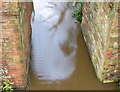
The Lagan canal, Ballyskeagh (November 2014)
The view from this footbridge Image showing the full, muddy and disused Lagan canal as it passes under the Ballyskeagh High Bridge on the Ballyskeagh Road. Image (February 2009) shows the canal at a much lower level.
Image: © Albert Bridge
Taken: 15 Nov 2014
0.18 miles
10
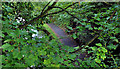
The Lagan towpath, Ballyskeagh
The summer leaves almost hiding the view, from the footbridge Image beside the Ballyskeagh High Bridge, of this part of the Lagan towpath Image
Image: © Albert Bridge
Taken: 18 Jun 2011
0.18 miles