IMAGES TAKEN NEAR TO
Traherne Gardens, LISBURN, BT27 5QW
Introduction
This page details the photographs taken nearby to Traherne Gardens, BT27 5QW by members of the Geograph project.
The Geograph project started in 2005 with the aim of publishing, organising and preserving representative images for every square kilometre of Great Britain, Ireland and the Isle of Man.

There are currently over 7.5m images from over14,400 individuals and you can help contribute to the project by visiting https://www.geograph.org.uk
Image Map
Images are licensed for reuse under creativecommons.org/licenses/by-sa/2.0
Notes
- Clicking on the map will re-center to the selected point.
- The higher the marker number, the further away the image location is from the centre of the postcode.
Image Listing (45 Images Found)
Images are licensed for reuse under creativecommons.org/licenses/by-sa/2.0
Image
Details
Distance
1

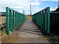
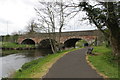
The Ravarnet bridge, Lisburn (1)
See Image The view along the Hillsborough Old Road towards the centre of Lisburn, as it crosses the Ravarnet River Image The framing creates the illusion that this is a rural stretch of road. In reality it’s suburban and includes the commercial area at the Altona Road. Continue to Image
Image: © Albert Bridge
Taken: 12 Mar 2010
0.09 miles
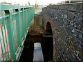
2
The Ravarnet bridge, Lisburn (2)
Image: © Albert Bridge
Taken: 12 Mar 2010
0.09 miles
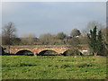
3
The Ravarnet bridge, Lisburn (3)
Image: © Albert Bridge
Taken: 12 Mar 2010
0.09 miles
4
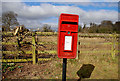
Letter box, Lisburn (1)
Post-mounted EIIR box on the Hillsborough Old Road, to the north east of the Ravarnet bridge Image
Image: © Albert Bridge
Taken: 12 Mar 2010
0.09 miles
5

"Road narrows" sign, Lisburn
Road narrows on both sides sign, on the approach to the Ravarnet bridge Image, on the Hillsborough Old Road.
Image: © Albert Bridge
Taken: 12 Mar 2010
0.10 miles
6
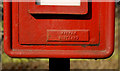
Letter box, Lisburn (2)
See Image The plate showing that the box was made by Machans of Denny.
Image: © Albert Bridge
Taken: 12 Mar 2010
0.11 miles
7

Grahamston manhole cover, Lisburn
See Image Although no longer made, Grahamston covers remain common. This one, on the Hillsborough Old Road, differs from the one in the link in design and in not showing the name “Falkirk” as the foundry’s address. It is also a Grade “B”.
Image: © Albert Bridge
Taken: 8 Nov 2010
0.12 miles
8
Lagan towpath
Approaching Moore's Bridge near Lisburn
Image: © Robert Ashby
Taken: 29 Apr 2015
0.12 miles
9
Moore's Bridge
Carries the A1 over the River Lagan south of Lisburn.
Image: © Brian Shaw
Taken: 29 Nov 2005
0.12 miles
10
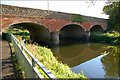
Moore's Bridge near Lisburn
Moore’s Bridge carries the Hillsborough Road across the Lagan. The view is downstream. See also Image
Image: © Albert Bridge
Taken: 17 Oct 2007
0.12 miles