IMAGES TAKEN NEAR TO
Greenavon Mews, Ballynahinch Road, LISBURN, BT27 5HA
Introduction
This page details the photographs taken nearby to Greenavon Mews, Ballynahinch Road, BT27 5HA by members of the Geograph project.
The Geograph project started in 2005 with the aim of publishing, organising and preserving representative images for every square kilometre of Great Britain, Ireland and the Isle of Man.

There are currently over 7.5m images from over14,400 individuals and you can help contribute to the project by visiting https://www.geograph.org.uk
Image Map
Images are licensed for reuse under creativecommons.org/licenses/by-sa/2.0
Notes
- Clicking on the map will re-center to the selected point.
- The higher the marker number, the further away the image location is from the centre of the postcode.
Image Listing (41 Images Found)
Images are licensed for reuse under creativecommons.org/licenses/by-sa/2.0
Image
Details
Distance
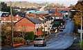
1
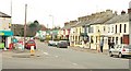
The Hillsborough Old Road, Lisburn
Before the horseless carriage and the building of the present line Image this was the main road to Hillsborough and Dublin. It rejoins the present road near Image The Ballynahinch Road Image is at bottom left. Continue to Image
Image: © Albert Bridge
Taken: 18 Feb 2009
0.04 miles
2
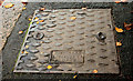
Robt Kirk manhole cover, Lisburn
See Image Another (of a different shape and design) from the same foundry. On the Hillsborough Old Road opposite The Close.
Image: © Albert Bridge
Taken: 8 Nov 2010
0.05 miles
3
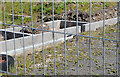
Vacant development site, Lisburn (2013-2)
See Image Foundations beside the Ballynahinch Road. There are other bits of uncompleted work elsewhere on the site.
Image: © Albert Bridge
Taken: 4 Aug 2013
0.06 miles
4
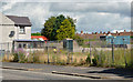
Vacant development site, Lisburn (2013-1)
Part of a site, on the eastern side of the Ballynahinch Road almost opposite here Image, where there had been a small amount of preliminary work Image which was never finished. Not the same as this one Image (April 2010).
Image: © Albert Bridge
Taken: 4 Aug 2013
0.07 miles
5

Car showroom, Lisburn (2013-1)
A Volkswagen dealership on the Ballynahinch Road.
Image: © Albert Bridge
Taken: 4 Aug 2013
0.09 miles
6

Car showroom, Lisburn (2013-2)
See Image The Volkswagen logo outside the premises. This link explains its origin http://www.dastank.com/Volkswagen-Logo-History.htm.
Image: © Albert Bridge
Taken: 4 Aug 2013
0.09 miles
7
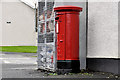
Pillar box, Lisburn
EIIR pillar box, on the Hillsborough Old Road, at the corner of the Ballynahinch Road.
Image: © Albert Bridge
Taken: 4 Dec 2011
0.10 miles
8
The Hillsborough Old Road, Lisburn (3)
See Image The view, downhill, towards the Ballynahinch Road. The north western end of the Altona Road is at bottom right – beside the lampposts.
Image: © Albert Bridge
Taken: 8 Nov 2010
0.11 miles
9

Ava Street, Lisburn
A short street off Young Street (the name under which it appears on the Google map). In the Belfast Metropolitan Area Plan to 2015 it comes under the description “There are a number of established residential areas at the above locations in Lisburn City Centre, and the Department recognises the importance of maintaining these communities.”
Image: © Albert Bridge
Taken: 24 Aug 2010
0.14 miles
10
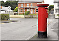
Pillar box, Lisburn
EIIR pillar box at Kensington Park off the Ballynahinch Road (background). It can be seen, in its setting, on the left in Image
Image: © Albert Bridge
Taken: 4 Dec 2011
0.15 miles