IMAGES TAKEN NEAR TO
Cromwell Close, LISBURN, BT27 5DL
Introduction
This page details the photographs taken nearby to Cromwell Close, BT27 5DL by members of the Geograph project.
The Geograph project started in 2005 with the aim of publishing, organising and preserving representative images for every square kilometre of Great Britain, Ireland and the Isle of Man.

There are currently over 7.5m images from over14,400 individuals and you can help contribute to the project by visiting https://www.geograph.org.uk
Image Map
Images are licensed for reuse under creativecommons.org/licenses/by-sa/2.0
Notes
- Clicking on the map will re-center to the selected point.
- The higher the marker number, the further away the image location is from the centre of the postcode.
Image Listing (91 Images Found)
Images are licensed for reuse under creativecommons.org/licenses/by-sa/2.0
Image
Details
Distance
1
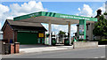
Petrol station, Lisburn
A small, independent petrol station http://www.laganoils.com/ on the Hillhall Road.
Image: © Albert Bridge
Taken: 4 Aug 2013
0.02 miles
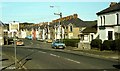
2
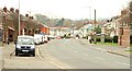
The Hillhall Road, Lisburn
Now part of the back road to Belfast via Image, the Hillhall Road was (I think) part of the main road before the building of the turnpike in the early 19th century. The brick pillars (middle right) mark the entrance to the Hillhall estate. The view is towards Mercer Street and the centre of Lisburn.
Image: © Albert Bridge
Taken: 18 Feb 2009
0.07 miles
3
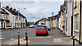
Gregg Street, Lisburn
Gregg Street runs from Mercer Street (behind me) to Canal Street. Mercer Street and Gregg Street can be seen in this view Image taken in 1982.
Image: © Albert Bridge
Taken: 21 Aug 2011
0.08 miles
4
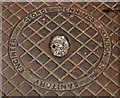
Jennings access cover, Lisburn (2)
Image: © Albert Bridge
Taken: 21 Aug 2011
0.08 miles
5
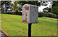
Drop box, Lisburn
Drop box, near the Hillhall Road end of Hillhall Gardens Image
Image: © Albert Bridge
Taken: 20 Sep 2011
0.08 miles
6
Mercer Street and Gregg Street, Lisburn
Mercer Street (right to left in the foreground) and Gregg Street, in the days before Lisburn became a city (note the pre-Worboys sign “Town Centre” at middle left). This is the Co Down side of the Lagan although the postal address of Lisburn is Co Antrim.
Image: © Albert Bridge
Taken: 11 Sep 1982
0.10 miles
7
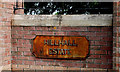
Hillhall estate sign, Lisburn
Old metal sign with welded letters, mounted on a modern pillar, at the entrance to the Hillhall estate, on the Hillhall Road.
Image: © Albert Bridge
Taken: 3 Jun 2010
0.10 miles
8

Cromwell's Highway sign, Lisburn
A street off the Saintfield Road named after the general and Lord Protector. Other streets in the area are also named after generals (Templar, Dill, Alanbrooke).
Image: © Albert Bridge
Taken: 4 Dec 2011
0.12 miles
9
Former furniture factory, Lisburn
The former “Tru-Style” furniture factory on the Saintfield Road. It closed about eight years ago and became a furniture showroom. Now occupied by a charity.
Image: © Albert Bridge
Taken: 4 Aug 2013
0.12 miles
10
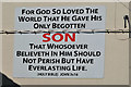
Biblical message, Lisburn
A familiar message, on a gable wall, almost opposite Mercer Street.
Image: © Albert Bridge
Taken: 4 Aug 2013
0.12 miles