IMAGES TAKEN NEAR TO
Queensway, LISBURN, BT27 4QN
Introduction
This page details the photographs taken nearby to Queensway, BT27 4QN by members of the Geograph project.
The Geograph project started in 2005 with the aim of publishing, organising and preserving representative images for every square kilometre of Great Britain, Ireland and the Isle of Man.

There are currently over 7.5m images from over14,400 individuals and you can help contribute to the project by visiting https://www.geograph.org.uk
Image Map
Images are licensed for reuse under creativecommons.org/licenses/by-sa/2.0
Notes
- Clicking on the map will re-center to the selected point.
- The higher the marker number, the further away the image location is from the centre of the postcode.
Image Listing (37 Images Found)
Images are licensed for reuse under creativecommons.org/licenses/by-sa/2.0
Image
Details
Distance
1
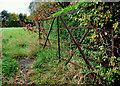
Gate near Derriaghy and Lambeg
A gate, leading to a field on the Derriaghy side of the Lambeg roundabout at Queensway.
Image: © Albert Bridge
Taken: 26 Oct 2010
0.04 miles
2
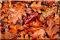
Autumn leaves near Lambeg
Much of the north eastern side of the McKinstry Road Image was lined by fallen autumn leaves.
Image: © Albert Bridge
Taken: 26 Oct 2010
0.06 miles
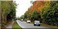
3
McKinstry Road, Lambeg (July 2018)
The McKinstry Road, from close to the power lines, looking towards Suffolk - a well-landscaped stretch of road.
Image: © Albert Bridge
Taken: 7 Jul 2018
0.08 miles
4
The McKinstry Road, Lambeg (2)
See Image The view, in the other direction, towards the roundabout at Queensway, between Lambeg and Derriaghy.
Image: © Albert Bridge
Taken: 26 Oct 2010
0.09 miles
5
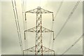
Pylon and power lines near Lambeg
Pylon and power lines across Queensway between Lambeg and Derriaghy – seen from Bell’s Lane Park. The continuation of the grid from Image
Image: © Albert Bridge
Taken: 20 Jul 2009
0.10 miles
6
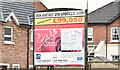
The Rose Garden, Derriaghy - April 2016(1)
The agents’ “for sale” board facing Queensway. It gives the address as “Belfast” (cough, splutter).
Image: © Albert Bridge
Taken: 14 Apr 2016
0.11 miles
7
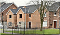
The Rose Garden, Derriaghy - April 2016(2)
Work continuing at the south western end of the site.
Image: © Albert Bridge
Taken: 14 Apr 2016
0.11 miles
8
BMX track, Lambeg
To the best of my memory Lisburn Borough Council built this BMX track, at what is now the Bell’s Lane amenity area, more than 30 years ago when it was one of the first (if not the first) in NI. I haven’t seen it in use in recent years so it might be a former BMX track. Now a popular place to walk the dog. Image shows it after rebuilding.
Image: © Albert Bridge
Taken: 27 May 2013
0.11 miles
9
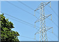
Pylon and power lines, Lambeg (July 2018)
See Image (July 2009). The same pylon, almost nine years later, seen from the McKinstry Road.
Image: © Albert Bridge
Taken: 7 Jul 2018
0.11 miles
10
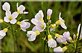
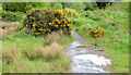
Cuckoo flower/Lady's Smock, Lambeg
Cuckoo flower/Lady’s Smock http://www.habitas.org.uk/flora/species.asp?item=2872 growing quite profusely in many damp spots around the Bell’s Lane amenity area.
Image: © Albert Bridge
Taken: 27 May 2013
0.12 miles