IMAGES TAKEN NEAR TO
Rockview Park, HILLSBOROUGH, BT26 6QN
Introduction
This page details the photographs taken nearby to Rockview Park, BT26 6QN by members of the Geograph project.
The Geograph project started in 2005 with the aim of publishing, organising and preserving representative images for every square kilometre of Great Britain, Ireland and the Isle of Man.

There are currently over 7.5m images from over14,400 individuals and you can help contribute to the project by visiting https://www.geograph.org.uk
Image Map
Images are licensed for reuse under creativecommons.org/licenses/by-sa/2.0
Notes
- Clicking on the map will re-center to the selected point.
- The higher the marker number, the further away the image location is from the centre of the postcode.
Image Listing (6 Images Found)
Images are licensed for reuse under creativecommons.org/licenses/by-sa/2.0
Image
Details
Distance
1
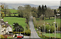
The Dromara Road, Drumlough
There is little difference in the heights of Hillsborough and Dromara but the Hillsborough – Dromara road rises and falls as it makes its way through the Co Down drumlins. This view, towards Dromara, shows the road passing the hamlet of Drumlough. The low cloud (background) on the Dromara Hills gives an indication of today’s weather.
Image: © Albert Bridge
Taken: 9 Apr 2012
0.07 miles
2
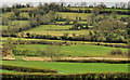
Countryside, Drumlough near Hillsborough
Fields on the south western side of the Dromara Road Image at Drumlough. The road rises and falls as it makes its way through the Co Down drumlins. There is little evidence of drumlins in this view of the agricultural land which is fairly typical of the local scenery.
Image: © Albert Bridge
Taken: 9 Apr 2012
0.08 miles
6
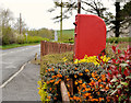
Letter box, Drumlough near Hillsborough
Post-mounted EIIR letter box (BT26 10) beside the Dromara Road, on the Hillsborough side of the crossroads.
Image: © Albert Bridge
Taken: 9 Apr 2012
0.23 miles