IMAGES TAKEN NEAR TO
The Pines, HILLSBOROUGH, BT26 6NT
Introduction
This page details the photographs taken nearby to The Pines, BT26 6NT by members of the Geograph project.
The Geograph project started in 2005 with the aim of publishing, organising and preserving representative images for every square kilometre of Great Britain, Ireland and the Isle of Man.

There are currently over 7.5m images from over14,400 individuals and you can help contribute to the project by visiting https://www.geograph.org.uk
Image Map
Images are licensed for reuse under creativecommons.org/licenses/by-sa/2.0
Notes
- Clicking on the map will re-center to the selected point.
- The higher the marker number, the further away the image location is from the centre of the postcode.
Image Listing (20 Images Found)
Images are licensed for reuse under creativecommons.org/licenses/by-sa/2.0
Image
Details
Distance
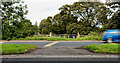
1
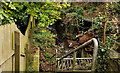
Mill race, Hillsborough
The old mill race (mentioned in Image) as it flows under the Culcavy Road, opposite The Pines. Well hidden from view and only visible to those on foot. No public access.
Image: © Albert Bridge
Taken: 24 Dec 2011
0.04 miles
2
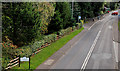
The Culcavey Road, Hillsborough (2)
See Image The view, towards Hillsborough, along the Culcavey Road, from the bypass flyover.
Image: © Albert Bridge
Taken: 2 Oct 2010
0.05 miles
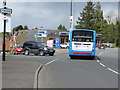
3
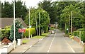
The Culcavey Road, Hillsborough
The Culcavey (also “Culcavy”) Road runs from the Lisburn Road to the much-expanded village beyond the bypass flyover (just visible at middle right).
Image: © Albert Bridge
Taken: 14 Jul 2009
0.06 miles
4
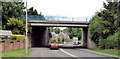
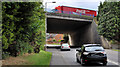
Flyover, Hillsborough (1)
The flyover carrying the Hillsborough bypass across the Culcavy (also Culcavey) Road. The view is towards Culcavy with Belfast to the right.
Image: © Albert Bridge
Taken: 8 Jun 2011
0.07 miles
5
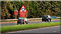
Roundabout signs, Hillsborough bypass
Two signs, beside the northbound carriageway, on the approach to the Hillsborough roundabout Image
Image: © Albert Bridge
Taken: 2 Oct 2010
0.08 miles
6
Central reservation gap, Hillsborough bypass (3)
A gap, in the central reservation, on top of the flyover across the Culcavey Road Image The southbound carriageway is in the foreground.
Image: © Albert Bridge
Taken: 2 Oct 2010
0.08 miles
7
Flyover, Hillsborough (2)
The flyover carrying the Hillsborough bypass across the Culcavy (also Culcavey) Road. The view is towards Hillsborough with Belfast to the left.
Image: © Albert Bridge
Taken: 8 Jun 2011
0.08 miles
9
Central reservation gap, Hillsborough bypass (4)
A gap, between the Culcavey Road flyover and the roundabout, originally intended (I think) to serve the field in the background. The southbound carriageway is in the foreground.
Image: © Albert Bridge
Taken: 2 Oct 2010
0.15 miles
10
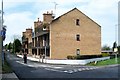
Road Junction
Junction of Lisburn Road and Culcavey Road in Hillsborough.
Image: © Robert Ashby
Taken: 29 Apr 2015
0.16 miles