IMAGES TAKEN NEAR TO
Magheradartin Road, HILLSBOROUGH, BT26 6LY
Introduction
This page details the photographs taken nearby to Magheradartin Road, BT26 6LY by members of the Geograph project.
The Geograph project started in 2005 with the aim of publishing, organising and preserving representative images for every square kilometre of Great Britain, Ireland and the Isle of Man.

There are currently over 7.5m images from over14,400 individuals and you can help contribute to the project by visiting https://www.geograph.org.uk
Image Map
Images are licensed for reuse under creativecommons.org/licenses/by-sa/2.0
Notes
- Clicking on the map will re-center to the selected point.
- The higher the marker number, the further away the image location is from the centre of the postcode.
Image Listing (5 Images Found)
Images are licensed for reuse under creativecommons.org/licenses/by-sa/2.0
Image
Details
Distance
1
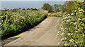
Magheradartin Road, Hillsborough
Townland of Magheradartin.
Image: © Dean Molyneaux
Taken: 12 Sep 2009
0.14 miles
2
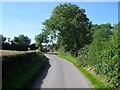
The Magheradartin Road near Hillsborough
Part of a minor road, lined today with spring flowers, running from the Windmill Road to the Hillsborough – Comber Road at Watson’s Bridge.
Image: © Albert Bridge
Taken: 27 May 2012
0.16 miles
3
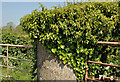
Gatepost near Hillsborough
An ivy-clad gatepost, supporting two gates, beside the Magheradartin Road Image
Image: © Albert Bridge
Taken: 27 May 2012
0.17 miles
4
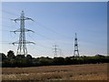
Pylons at Magheradartin
The main power line from Belfast to County Armagh passes through the townland of Magheradartin near Hillsborough. The line is met by another from Lisburn.
Image: © Dean Molyneaux
Taken: 12 Sep 2009
0.18 miles
5
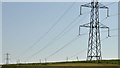
Pylons and power lines near Hillsborough (3)
Pylons and power lines approaching the Magheradartin Road Image They have come from the direction of Legacurry and Carryduff.
Image: © Albert Bridge
Taken: 27 May 2012
0.22 miles