IMAGES TAKEN NEAR TO
Lany Road, HILLSBOROUGH, BT26 6JR
Introduction
This page details the photographs taken nearby to Lany Road, BT26 6JR by members of the Geograph project.
The Geograph project started in 2005 with the aim of publishing, organising and preserving representative images for every square kilometre of Great Britain, Ireland and the Isle of Man.

There are currently over 7.5m images from over14,400 individuals and you can help contribute to the project by visiting https://www.geograph.org.uk
Image Map
Images are licensed for reuse under creativecommons.org/licenses/by-sa/2.0
Notes
- Clicking on the map will re-center to the selected point.
- The higher the marker number, the further away the image location is from the centre of the postcode.
Image Listing (10 Images Found)
Images are licensed for reuse under creativecommons.org/licenses/by-sa/2.0
Image
Details
Distance
3
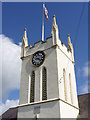
Clock tower at St. James's Parish Church, Lower Kilwarlin
Image: © HENRY CLARK
Taken: 25 Jul 2009
0.06 miles
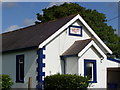
4
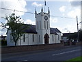
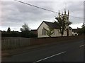
St. James's Parish Church, Lower Kilwarlin
http://www.lisburn.com/churches/Lisburn-churches/st-jamess-lower-kilwarlin.html
Image: © HENRY CLARK
Taken: 25 Jul 2009
0.08 miles
6
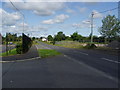
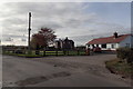
Lany Road,Lower Kilwarlin
Taken close to St. James's Parish Church, Lower Kilwarlin,to the left is Meadow Bridge Primary School with Halliday's Bridge Orange Hall on the right hand side of the road.
Image: © HENRY CLARK
Taken: 25 Jul 2009
0.11 miles
7
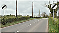
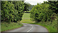
The Lany Road, Halliday's Bridge, Hillsborough/Moira (April 2017)
See Image The minor Lany Road, heading towards Moira, at the end of the short 40mph restriction through Halliday’s Bridge. For reference purposes the pumping station is just behind me to the left.
Image: © Albert Bridge
Taken: 18 Apr 2017
0.12 miles
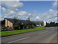
9
The Moira Road near Hillsborough
See Image and Image The Moira Road, on the Moira side of the Beechfield Bridge Image across the M1. Some of the road follows a course through the flat countryside between the M1 and the Lagan. This stretch is an exception. The St James Road runs off to the right (lower middle).
Image: © Albert Bridge
Taken: 23 Jun 2012
0.19 miles