1
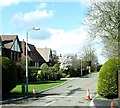
Kensington Gardens, Hillsborough
This is a new estate on the outskirts of Hillsborough. The town has increasingly become a dormitory settlement for white collar commuters to Belfast and Lisburn.
Image: © Eric Jones
Taken: 2 Apr 2011
0.05 miles
2
Flowering rape, Hillsborough (1)
Rape flowering in a field between the Lisburn Road and the bypass. I’m not very knowledgeable about agricultural matters but it seemed to pass very quickly from just a few flowers to what you see here. See also
Image
Image: © Albert Bridge
Taken: 9 Apr 2012
0.09 miles
3
Barley field, Hillsborough (1)
Part of a large field of barley, between the Lisburn Road and the southern side of Carnreagh.
Image: © Albert Bridge
Taken: 8 Jun 2011
0.12 miles
4
Gate, Hillsborough
A gate, leading to a field of ripening barley, off the Lisburn Road.
Image: © Albert Bridge
Taken: 2 Jul 2011
0.12 miles
5
Central reservation gap, Hillsborough bypass (4)
A gap, between the Culcavey Road flyover and the roundabout, originally intended (I think) to serve the field in the background. The southbound carriageway is in the foreground.
Image: © Albert Bridge
Taken: 2 Oct 2010
0.12 miles
6
Flowering rape. Hillsborough (2)
Rape flowering in another part of this field
Image beside the Lisburn Road (out of picture to the right).
Image: © Albert Bridge
Taken: 9 Apr 2012
0.13 miles
7
"The Marquis of Downshire"
A very pleasant pub on Lisburn Street in Hillsborough (just opposite the Presbyterian Church).
Image: © Brian Shaw
Taken: 9 Nov 2005
0.13 miles
8
One of a pair
This fine house in Lisburn Street, Hillsborough is a mirror image of the house to the right of it.
Image: © Brian Shaw
Taken: 9 Nov 2005
0.13 miles
9
Cropland east of Lisburn Road, Hillsborough
Image: © Eric Jones
Taken: 12 Oct 2012
0.13 miles
10
The Culcavey Road, Hillsborough
The Culcavey (also “Culcavy”) Road runs from the Lisburn Road to the much-expanded village beyond the bypass flyover (just visible at middle right).
Image: © Albert Bridge
Taken: 14 Jul 2009
0.17 miles


