IMAGES TAKEN NEAR TO
Anahilt Gate, HILLSBOROUGH, BT26 6GJ
Introduction
This page details the photographs taken nearby to Anahilt Gate, BT26 6GJ by members of the Geograph project.
The Geograph project started in 2005 with the aim of publishing, organising and preserving representative images for every square kilometre of Great Britain, Ireland and the Isle of Man.

There are currently over 7.5m images from over14,400 individuals and you can help contribute to the project by visiting https://www.geograph.org.uk
Image Map
Images are licensed for reuse under creativecommons.org/licenses/by-sa/2.0
Notes
- Clicking on the map will re-center to the selected point.
- The higher the marker number, the further away the image location is from the centre of the postcode.
Image Listing (21 Images Found)
Images are licensed for reuse under creativecommons.org/licenses/by-sa/2.0
Image
Details
Distance
1
The 0950 No26 Ulsterbus Service from Lisburn to Dromara on Magheraconluce Road
This bus does the return journey via Annahilt seven times each weekday and twice on Sunday.
Image: © Eric Jones
Taken: 12 Oct 2012
0.11 miles
2
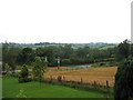
Farmland, Annahilt
Farmland on the outskirts of Annahilt, the derestriction signs are on the Ballynahinch Road in the foreground.
Image: © Sue Adair
Taken: 13 Aug 2008
0.12 miles
3
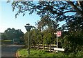
DUP Local Election Posters at the junction of Ballynahinch Road and Magheraconluce Road, Annahilt
Annahilt, where over 91% of the population are of a Protestant background, is natural Democratic Unionist Party (DUP) country. Of the 30 councilors on Lisburn City Council, 14 are DUP members.
Image: © Eric Jones
Taken: 5 May 2011
0.12 miles
4
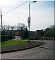
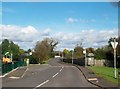
Approaching Ballycrune Crossroads, Annahilt
This is a staggered junction on the B77 (Ballynahinch-Hillsborough road). The attractive red and white building was formerly a group of alms houses.
Image: © Eric Jones
Taken: 31 Oct 2015
0.13 miles
5
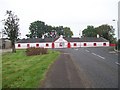
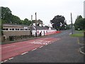
The old Alms Houses at Annahilt
The image was taken from Glebe Road across Ballycrune Crossroads.
Image: © Eric Jones
Taken: 31 Oct 2015
0.13 miles
6
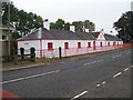
Former Alms Houses at Ballycrune Crossroads
These were built in the 1830s.
Image: © Eric Jones
Taken: 31 Oct 2015
0.13 miles
7
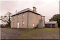
Orange Hall
Annahilt Orange Hall dating from 1882.
Image: © Robert Ashby
Taken: 20 Oct 2013
0.14 miles
8
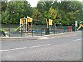
Children's Playground at Ballycrune Crossroads, Annahilt
Image: © Eric Jones
Taken: 31 Oct 2015
0.14 miles
10
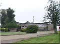
Annahilt Scouts Hall at Ballycrune Cross Roads
Image: © Eric Jones
Taken: 31 Oct 2015
0.16 miles