IMAGES TAKEN NEAR TO
Mill Brae, DROMORE, BT25 2QJ
Introduction
This page details the photographs taken nearby to Mill Brae, BT25 2QJ by members of the Geograph project.
The Geograph project started in 2005 with the aim of publishing, organising and preserving representative images for every square kilometre of Great Britain, Ireland and the Isle of Man.

There are currently over 7.5m images from over14,400 individuals and you can help contribute to the project by visiting https://www.geograph.org.uk
Image Map
Images are licensed for reuse under creativecommons.org/licenses/by-sa/2.0
Notes
- Clicking on the map will re-center to the selected point.
- The higher the marker number, the further away the image location is from the centre of the postcode.
Image Listing (4 Images Found)
Images are licensed for reuse under creativecommons.org/licenses/by-sa/2.0
Image
Details
Distance
1
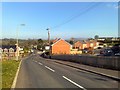
Waringsford Village
This is Waringsford village, looking east, with Slieve Croob as a backdrop. The village has seen significant development since the year 2000 - two examples of which are evident in the image. The mini-roundabout in the distance was laid in 2008 and caused quite a lot of controversy - it remains ignored by some motorists.
Image: © Dean Molyneaux
Taken: 20 Apr 2009
0.05 miles
2
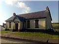
Waringsford Orange Hall
This is the Orange Hall in Waringsford village. It was constructed in 1907 and is sited on the Tullinisky Road - in the village centre.
Image: © Dean Molyneaux
Taken: 20 Apr 2009
0.07 miles
3
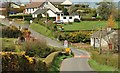
Eirford Park, Waringsford
Eirford Park is a small cul-de-sac comprising of twelve cottage bungalows. This is one of the older developments in Waringsford village. It is situated on the Enagh Road in the townland of Tullinisky.
Image: © Dean Molyneaux
Taken: 19 Apr 2009
0.09 miles
4
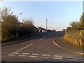
The Enagh Road, Waringsford
Although not apparent here, Waringsford has expanded with many new houses built in recent years. This is the approach from the Castlewellan direction.
Image: © Albert Bridge
Taken: 11 Apr 2009
0.17 miles