IMAGES TAKEN NEAR TO
Tannaghmore Road, BALLYNAHINCH, BT24 8NT
Introduction
This page details the photographs taken nearby to Tannaghmore Road, BT24 8NT by members of the Geograph project.
The Geograph project started in 2005 with the aim of publishing, organising and preserving representative images for every square kilometre of Great Britain, Ireland and the Isle of Man.

There are currently over 7.5m images from over14,400 individuals and you can help contribute to the project by visiting https://www.geograph.org.uk
Image Map
Images are licensed for reuse under creativecommons.org/licenses/by-sa/2.0
Notes
- Clicking on the map will re-center to the selected point.
- The higher the marker number, the further away the image location is from the centre of the postcode.
Image Listing (13 Images Found)
Images are licensed for reuse under creativecommons.org/licenses/by-sa/2.0
Image
Details
Distance
1
Bogland below Bohill Wood
The image was taken from Tannaghmore Road.
Image: © Eric Jones
Taken: 12 May 2016
0.13 miles
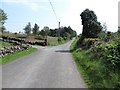
2
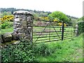
Traditional Ulster pillared gateway on Tannaghmore Road
When Google Streetview passed by in March 2011 the pillar nearest the camera was under construction.
http://www.instantstreetview.com/@54.341829,-5.850428,-88.83h,-0.94p,1z
Image: © Eric Jones
Taken: 12 May 2016
0.13 miles
3
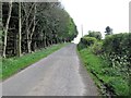
Forest plantation on the east side of Tannaghmore Road
Image: © Eric Jones
Taken: 12 May 2016
0.14 miles
4
Bird reserve on the eastern edge of Bohill Wood
Image: © Eric Jones
Taken: 12 May 2016
0.14 miles
5
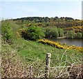
The western edge of Bohill Wood viewed across Tannaghmore Reservoir
Bohill Wood is owned by the NI Forestry Service.
Image: © Eric Jones
Taken: 12 May 2016
0.14 miles
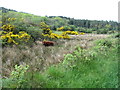
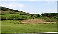
7
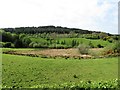
Drumlins and an inter-drumlin wet-land hollow on the west side of Tannaghmore Road
Bohill Wood forms the background.
Image: © Eric Jones
Taken: 12 May 2016
0.17 miles
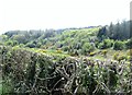
9
Inter-drumlin wetland north-west of Tannaghmore Road
The forest behind is the state owned Bohill Wood.
Image: © Eric Jones
Taken: 12 May 2016
0.20 miles
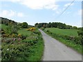
10
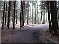
Bend in the Bohill Wood track
Bohill Wood is accessed from Tannaghmore Road. The forest is owned by the NI Forestry Service. The notice on the gate warns of the presence of Japanese larch disease and forbids the removal of any wood from the forest. The disease is caused by a fungus-like pathogen known as Phytophthora ramorum.
Image: © Eric Jones
Taken: 12 May 2016
0.20 miles