IMAGES TAKEN NEAR TO
Frances Street, NEWTOWNARDS, BT23 7DN
Introduction
This page details the photographs taken nearby to Frances Street, BT23 7DN by members of the Geograph project.
The Geograph project started in 2005 with the aim of publishing, organising and preserving representative images for every square kilometre of Great Britain, Ireland and the Isle of Man.

There are currently over 7.5m images from over14,400 individuals and you can help contribute to the project by visiting https://www.geograph.org.uk
Image Map
Images are licensed for reuse under creativecommons.org/licenses/by-sa/2.0
Notes
- Clicking on the map will re-center to the selected point.
- The higher the marker number, the further away the image location is from the centre of the postcode.
Image Listing (227 Images Found)
Images are licensed for reuse under creativecommons.org/licenses/by-sa/2.0
Image
Details
Distance
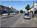
1
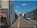
Ann Street, Newtownards
Ann Street runs north from Frances Street.
Image: © Eric Jones
Taken: 2 Aug 2013
0.02 miles
2
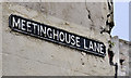
Meetinghouse Lane, Newtownards (2)
See Image The cast name sign at the Frances Street end.
Image: © Albert Bridge
Taken: 26 Jun 2011
0.03 miles
3
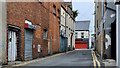
Meetinghouse Lane, Newtownards (1)
A narrow street running from High Street to Frances Street (background). The “meetinghouse” might have been the 1670 predecessor of today’s First Presbyterian church. See also Image
Image: © Albert Bridge
Taken: 26 Jun 2011
0.03 miles
4
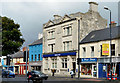
The Ulster Bank, Newtownards
See Image The Ulster Bank at 22 Frances Street, built from Portland stone, opened in 1926 on the site of its predecessor of 1865. Not a listed building but mentioned on the list as “the facade has been added to on several occasions and is now modern, functional”. Once known as “Mackintosh’s bank” after the first manager, Patrick Mackintosh, who was also a Justice of the Peace who held court in a room in the original building. Continue to Image
Image: © Albert Bridge
Taken: 9 Oct 2013
0.04 miles
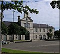
6
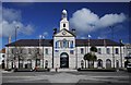
The Town Hall, Newtownards
Standing in Conway Square, this was originally the Market House for Newtownards. The market took place on the ground floor, the upper floors containing assembly rooms. The building saw action during the 1798 rebellion and was seized by the United Irishmen heading towards Saintfield; later rebels were held in cells below the Market House.
By the end of the 19th Century the building was in use as a Town Hall. Today it is home to Ards Art Centre and hosts exhibitions and music recitals. Conway Square in the foreground still hosts a weekly market every Saturday.
A flush bracket bench mark, numbered OSBM 3455, was located on the north-eastern tip of the building but this has been destroyed (probably during renovations c2002).
Image: © Rossographer
Taken: 1 Apr 2010
0.05 miles
8
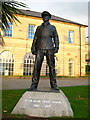
Blair Mayne statue, Newtownards
Lieutenant-Colonel Robert Blair ('Paddy') Mayne DSO & 3 Bars (11 January 1915 - 14 December 1955) was a Northern Irish soldier, solicitor, rugby union international, amateur boxer and polar explorer.
See http://en.wikipedia.org/wiki/Robert_Blair_Mayne for more information.
Image: © Rossographer
Taken: 29 Dec 2007
0.05 miles
9
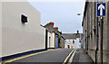
Price's Lane, Newtownards
A narrow one-way street running from Frances Street to East Street (background). The wall (right) is the First Presbyterian church. See also Image
Image: © Albert Bridge
Taken: 26 Jun 2011
0.05 miles
10
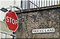
Price's Lane name sign, Newtownards (January 2017)
See Image The name sign (without the apostrophe) at the East Street end. I can’t find many web references but the Ards Historical Society http://www.ardshistoricalsociety.org.uk/ has this “An interesting feature of the town was the 'Back Street' which apparently consisted of a single row of houses stretching from Price's Lane to Mary Street and lying between Francis street and East street; the general line and indeed some of the individual houses can still be traced.”
Image: © Albert Bridge
Taken: 24 Jan 2017
0.06 miles