IMAGES TAKEN NEAR TO
Moate Road, NEWTOWNARDS, BT23 4XA
Introduction
This page details the photographs taken nearby to Moate Road, BT23 4XA by members of the Geograph project.
The Geograph project started in 2005 with the aim of publishing, organising and preserving representative images for every square kilometre of Great Britain, Ireland and the Isle of Man.

There are currently over 7.5m images from over14,400 individuals and you can help contribute to the project by visiting https://www.geograph.org.uk
Image Map
Images are licensed for reuse under creativecommons.org/licenses/by-sa/2.0
Notes
- Clicking on the map will re-center to the selected point.
- The higher the marker number, the further away the image location is from the centre of the postcode.
Image Listing (22 Images Found)
Images are licensed for reuse under creativecommons.org/licenses/by-sa/2.0
Image
Details
Distance
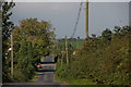
1
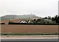
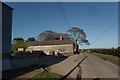
House and farm buildings on the Moat Road
A rain shower partly obscures Scrabo Hill in the background.
Image: © Eric Jones
Taken: 22 Apr 2017
0.08 miles
2
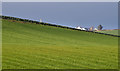
Drumlins, Comber/Newtownards
Standard north Down drumlins, south of Scrabo, to the west of the Comber/Newtownards road.
Image: © Albert Bridge
Taken: 11 Jan 2014
0.09 miles
3
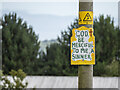
Religious message near Comber
"God be merciful to me a sinner" on a telegraph pole between Comber and Newtownards. One of several, each bearing the same message.
Image: © Rossographer
Taken: 1 Aug 2022
0.13 miles
4
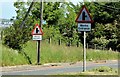
"Works entrance" roads signs, Comber/Newtownards (June 2015)
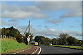
Two “road junction/side road” signs, beside the northbound lanes of the Comber – Newtownards dual carriageway, each with a plate referring to a works entrance on the right. The entrance, reached by a gap in the central reservation, leads to here Image
Image: © Albert Bridge
Taken: 11 Jun 2015
0.13 miles
6
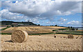
Straw bales near Scrabo
Rolled straw bales beneath Scrabo Tower between Comber and Newtownards.
Image: © Rossographer
Taken: 1 Aug 2022
0.15 miles
7
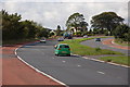
Longlands Road
Approaching the A21 between Comber and Newtonards.
Image: © Robert Ashby
Taken: 16 Nov 2016
0.17 miles
8
The Newtownards to Comber road
The road from Newtownards to Comber passes close to Strangford Lough and is almost at sea level. Part of it is dual carriageway. This is the view to Comber at Longlands. This area is known for producing “Comber” potatoes.
Image: © Albert Bridge
Taken: 29 Aug 2006
0.17 miles
9
The Longlands Road near Comber
The Longlands Road runs from the Newtownards–Comber road to join the Island Hill Road on its way to the shore of Strangford Lough. Many of the fields here are planted with potatoes. This is the view towards the main road.
Image: © Albert Bridge
Taken: 29 Aug 2006
0.17 miles
10
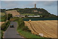
The Moate Road near Comber
The Moate Road is an unclassified road running from the Newtownards to Comber road towards the Newtownards-Belfast road. This is the view from near the former with Scrabo Tower on the hill at the top of the photo.
Image: © Albert Bridge
Taken: 19 Sep 2006
0.17 miles