IMAGES TAKEN NEAR TO
Mark Mews, NEWTOWNARDS, BT23 4GY
Introduction
This page details the photographs taken nearby to Mark Mews, BT23 4GY by members of the Geograph project.
The Geograph project started in 2005 with the aim of publishing, organising and preserving representative images for every square kilometre of Great Britain, Ireland and the Isle of Man.

There are currently over 7.5m images from over14,400 individuals and you can help contribute to the project by visiting https://www.geograph.org.uk
Image Map
Images are licensed for reuse under creativecommons.org/licenses/by-sa/2.0
Notes
- Clicking on the map will re-center to the selected point.
- The higher the marker number, the further away the image location is from the centre of the postcode.
Image Listing (202 Images Found)
Images are licensed for reuse under creativecommons.org/licenses/by-sa/2.0
Image
Details
Distance
1
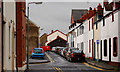
Robert Street, Newtownards
A very narrow street, running parallel to West Street, close to the back of the bus station. Wide enough to take a car but not a lorry.
Image: © Albert Bridge
Taken: 7 Feb 2011
0.03 miles
2
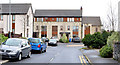
Mark Mews, Newtownards
A recent development of apartments on the eastern side of Thomas Street.
Image: © Albert Bridge
Taken: 5 Feb 2014
0.03 miles
3
McKeown grating cover, Newtownards
See Image Another McKeown’s Grosvenor Foundry http://www.geograph.org.uk/search.php?i=23884431 grating but without the patent number. This one is at the Robert Street end of Brewery Lane.
Image: © Albert Bridge
Taken: 11 Aug 2011
0.04 miles
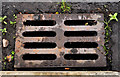
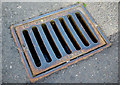
4
Gully grating, Newtownards
Grating on Mark Street in Newtownards. From the Grosvenor Foundry of J. & J. McKeown in Belfast, it also features the patent number - 34915/30. This was one of several noticed in the area.
Image: © Rossographer
Taken: 1 Jun 2011
0.04 miles
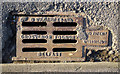
5
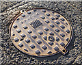
Manhole cover, Newtownards
Manhole cover located on Mark Street in Newtownards. It is marked "Briduc". The following is adapted from a Highway Engineers magazine report found on the Chartered Institute of Highways and Transportation:
"The Briduc was a lightweight cover made of ductile iron, but about four times as strong as the ordinary grey iron from which manhole covers are traditionally made. It was manufactured by Dunbro Ltd of Woolwich, London SE28, and introduced in 1973. It had a clear opening of 610mm diameter, which complied with safety recommendations for sewers. Although the opening was in excess of that normally specified for sewers in accordance with BS 497/67 the weight saving was dramatic, the cover weighing only 38 kg as against 140 kg for the normal cover weight of an ordinary 22" diameter roadway manhole cover. This weight saving allowed for easier transportation and cheaper site installation costs, safety in use, and a lower cost since less metal was used in its manufacture."
(Many thanks to Nigel Cox http://www.geograph.org.uk/profile/2798 for the above). See also Image for a closer view.
Image: © Rossographer
Taken: 1 Jun 2011
0.04 miles
6
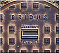
Manhole cover, Newtownards
Detail of the cover seen in Image located in Mark Street, Newtownards. This shows the name "Briduc" and the "Agrement Certificate No. 79/368".
Image: © Rossographer
Taken: 1 Jun 2011
0.04 miles
7
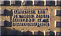
Manhole cover, Newtownards
Detail of a manhole cover located on Mark Street in Newtownards. It was made by Clarksteel of Peterboro, who are still trading as Clark-Drain Ltd. from Station Road, Yaxley, Peterborough http://www.clark-steel.com/ .
Image: © Rossographer
Taken: 1 Jun 2011
0.04 miles
8
Gully grating, Newtownards
Grating from the Millfield Foundry in Belfast, this example is located on Thomas Street in Newtownards. One of many from the foundry seen in the town.
Image: © Rossographer
Taken: 1 Jun 2011
0.05 miles
9

Solar panels, Newtownards (April 2016)
At Thomas Street.
Image: © Albert Bridge
Taken: 21 Apr 2016
0.06 miles
10
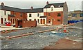
New apartments, Newtownards
New apartments and townhouses, in West Street, being built on the site of the old market yard Image
Image: © Albert Bridge
Taken: 23 Mar 2008
0.06 miles