IMAGES TAKEN NEAR TO
Main Street, NEWTOWNARDS, BT22 2SR

Introduction

This page details the photographs taken nearby to Main Street, BT22 2SR by members of the Geograph project.

The Geograph project started in 2005 with the aim of publishing, organising and preserving representative images for every square kilometre of Great Britain, Ireland and the Isle of Man.

There are currently over 7.5m images from over14,400 individuals and you can help contribute to the project by visiting https://www.geograph.org.uk

Image Map


Images are licensed for reuse under creativecommons.org/licenses/by-sa/2.0
Notes
  • Clicking on the map will re-center to the selected point.
  • The higher the marker number, the further away the image location is from the centre of the postcode.

Image Listing (22 Images Found)

Images are licensed for reuse under creativecommons.org/licenses/by-sa/2.0
  • ...
Image
Details
Distance
1
The Ulster Bank, Kircubbin
See Image The same comments apply to this branch of the Ulster Bank at Main Street. Continue to Image
Image: © Albert Bridge Taken: 25 Jul 2013
0.02 miles
2
Church clock, Kircubbin
The clock (not working) on the pediment of this church Image at Main Street.
Image: © Albert Bridge Taken: 25 Jul 2013
0.02 miles
3
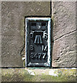
Flush Bracket, Kircubbin
Flush bracket located on the south-eastern tip of Holy Trinity Church, Kircubbin Image The number on the bracket is OSBM 3477 The mark is 9.77 metres above MSL. A flush bracket is a type of bench mark set onto the face of a building. See also http://www.geograph.org.uk/search.php?i=11037856 for many other examples I have found.
Image: © Rossographer Taken: 8 Aug 2010
0.03 miles
4
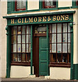
"Gilmore's", Kircubbin
Part of a listed (HB24/02/020) public house at 44 Main Street. The date of building is not specifically recorded but might be pre-1824. It is (to the layman) unaltered and an unusual survivor. Parked cars hindered a view of the entire premises. See also Image
Image: © Albert Bridge Taken: 30 Aug 2011
0.03 miles
5
Main Street, Kircubbin [1]
Looking south-east in the direction of Portaferry.
Image: © Rossographer Taken: 25 Mar 2008
0.04 miles
6
Main Street, Kircubbin [2]
Looking in the direction of Greyabbey.
Image: © Rossographer Taken: 25 Mar 2008
0.05 miles
7
Holy Trinity Church, Kircubbin
Holy Trinity (Church of Ireland) in Main Street, Kircubbin. Built 1843 to a design by Charles Lanyon in the style of a greek temple.
Image: © Rossographer Taken: 25 Mar 2008
0.05 miles
8
Bus, Kircubbin
An Ulsterbus Wright-bodied Volvo (2780 BCZ 2780) calling at the Main Street/Roden Street stop with the 09.55 Portaferry-Newtownards via Cloughey, Portavogie and Ballyhalbert.
Image: © Albert Bridge Taken: 25 Jul 2013
0.05 miles
9
Kircubbin Village from the air
A Sunday afternoon helicopter ride over Kircubbin district.
Image: © Ronan Magee Taken: 13 Jul 2008
0.06 miles
10
K6 telephone box, Kircubbin (2013-2)
See Image The door. Heavier that it looks and with stiff hinges; they inevitably required a hefty pull to open. Continue to Image
Image: © Albert Bridge Taken: 25 Jul 2013
0.08 miles
  • ...