IMAGES TAKEN NEAR TO
Richmond Crescent, BANGOR, BT20 5QD
Introduction
This page details the photographs taken nearby to Richmond Crescent, BT20 5QD by members of the Geograph project.
The Geograph project started in 2005 with the aim of publishing, organising and preserving representative images for every square kilometre of Great Britain, Ireland and the Isle of Man.

There are currently over 7.5m images from over14,400 individuals and you can help contribute to the project by visiting https://www.geograph.org.uk
Image Map
Images are licensed for reuse under creativecommons.org/licenses/by-sa/2.0
Notes
- Clicking on the map will re-center to the selected point.
- The higher the marker number, the further away the image location is from the centre of the postcode.
Image Listing (33 Images Found)
Images are licensed for reuse under creativecommons.org/licenses/by-sa/2.0
Image
Details
Distance
1
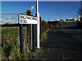
The Ballymacormick Road, Bangor
Road on the northern edge of Bangor leading from the East Circular Road. The northern side of the road is green belt and, aside from Ballymacormick House, all development is along the southern side of the road only. Image shows the very end of the road.
Image: © Rossographer
Taken: 30 Jan 2010
0.07 miles
2
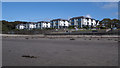
Apartments, Bangor
New apartments overlooking Ballyholme Bay on the eastern edge of Bangor. This is an "exclusive over 55's development" and "available for long term rental" rather than purchase according to https://showersave.com/recent-projects/the-banks-ballyholme/ though I can't find an agent currently.
Image: © Rossographer
Taken: 29 Aug 2020
0.11 miles
3
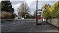
Telephone call box, Bangor
BT "KX 100" telephone box on Ashley Gardens, Bangor. Still working and in good condition. There was a K6 box here until the late 1990s.
Image: © Rossographer
Taken: 15 Feb 2021
0.14 miles
4
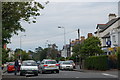
Groomsport Road, Ballyholme
Ballyholme is a suburb of Bangor almost entirely residential with a sprinkling of churches, banks, small shops, hairdressers and estate agents to serve the local inhabitants. Alas there is little (perhaps nothing) of historical or scenic interest so I offer this uninspiring shot of the Groomsport Road (the main street) looking towards the roundabout - gripping stuff!
Image: © Albert Bridge
Taken: 25 Jun 2006
0.15 miles
5
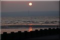
The setting sun over Ballyholme
The setting sun, over the beach, at Ballyholme. Kilroot power station Image, on the other side of Belfast Lough, is visible under the sun.
Image: © Albert Bridge
Taken: 4 Jun 2007
0.15 miles
6
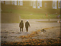
Ballyholme Beach, Bangor
Walkers enjoying the late afternoon sun on Ballyholme Beach http://www.geograph.org.uk/search.php?i=10396850 in Bangor. This photograph was taken directly towards the sun which was just setting behind the houses seen in the background.
Image: © Rossographer
Taken: 11 Dec 2010
0.16 miles
7
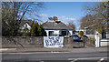
Banner, Bangor
Taken during the Covid-19 pandemic, a "We love our NHS staff, thank you" hand painted banner outside a house on the Groomsport Road, Bangor. Not far from this one Image
Image: © Rossographer
Taken: 29 Mar 2020
0.16 miles
8
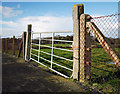
Field gate, Bangor
Gate leading to farmland from the Ballymacormick Road on the northern edge of Bangor.
Image: © Rossographer
Taken: 30 Jan 2010
0.17 miles
9

Ballyholme Beach at dusk
Ballyholme Beach, Bangor, shortly after sunset on a cold but still February evening. Random information: we had just watched the International Space Station http://en.wikipedia.org/wiki/International_Space_Station as it flew through space above us.
Image: © Rossographer
Taken: 18 Feb 2013
0.18 miles
10
![Ballyholme beach [5]](https://s0.geograph.org.uk/photos/80/25/802572_4908552d_120x120.jpg)
Ballyholme beach [5]
Looking back across the sands towards houses at Ballyholme in Bangor on a fine May evening.
Image: © Rossographer
Taken: 14 May 2008
0.18 miles