IMAGES TAKEN NEAR TO
Castle Street, BANGOR, BT20 4SX
Introduction
This page details the photographs taken nearby to Castle Street, BT20 4SX by members of the Geograph project.
The Geograph project started in 2005 with the aim of publishing, organising and preserving representative images for every square kilometre of Great Britain, Ireland and the Isle of Man.

There are currently over 7.5m images from over14,400 individuals and you can help contribute to the project by visiting https://www.geograph.org.uk
Image Map
Images are licensed for reuse under creativecommons.org/licenses/by-sa/2.0
Notes
- Clicking on the map will re-center to the selected point.
- The higher the marker number, the further away the image location is from the centre of the postcode.
Image Listing (432 Images Found)
Images are licensed for reuse under creativecommons.org/licenses/by-sa/2.0
Image
Details
Distance
1
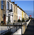
Terrace, Castle Street
Terrace on Castle Street in Bangor. Originally known as 'Castlemount Terrace' and constructed c1895.
Image: © Rossographer
Taken: 23 Oct 2009
0.01 miles
2
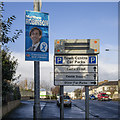
2019 Election poster, Bangor
Matthew Robinson for the Conservative and Unionist Party on Castle Street in Bangor.
Image: © Rossographer
Taken: 8 Dec 2019
0.04 miles
3
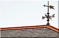
Weathervane, Bangor Hospital
A weathervane, on Bangor hospital Image, seen from Castle Street. It’s hard to be sure, given the distance, but the material might be copper.
Image: © Albert Bridge
Taken: 16 Mar 2014
0.05 miles
4
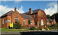
Bangor Hospital
The original wing of Bangor Hospital, constructed 1909-10 to a design by architects Young & Mackenzie. Two later extensions, unseen here, complete the building.
Closed to in-patients in 1996, it now operates as a local community hospital and minor injuries clinic.
Image: © Rossographer
Taken: 4 Oct 2009
0.06 miles
5
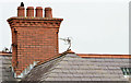
Chimney, Bangor Hospital
A chimney, with four pots, on Bangor hospital Image, seen from Castle Street. Looking at the photo of the hospital building it appears that chimneys (and presumably heat) were not considered essential at the time of construction.
Image: © Albert Bridge
Taken: 16 Mar 2014
0.06 miles
6
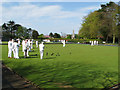
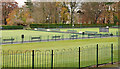
Ward Park bowling green, Bangor
Very popular in the summer months. From my 1901 OS map I think that this area was once a brick works.
Image: © Rossographer
Taken: 3 May 2008
0.07 miles
7
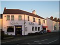
'Kaya', Bangor
For many years this was known as the 'Castle Arms' bar but has now been totally rebranded as the restaurant 'Kaya'. I think, however, that the ground floor is still the old bar with the restaurant occupying the first floor. The off-sales on the extreme right of the building is still known as the 'Castle Off Sales'.
Image: © Rossographer
Taken: 11 Feb 2008
0.07 miles
8
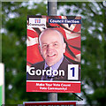
'Community Partnership (NI)' election poster, Bangor
Election poster for Mark Gordon of Community Partnership (Northern Ireland) who stood for the local council election in the Bangor Central District Electoral Area. He was unsuccessful. This was located on Castle Street in Bangor.
Image: © Rossographer
Taken: 15 May 2014
0.07 miles
9
Bowling greens, Bangor (2012)
See Image (September 2007). The bowling greens in Ward Park – out of season and deserted. Image shows them in use in May 2008.
Image: © Albert Bridge
Taken: 15 Nov 2012
0.07 miles
10
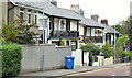
Park Drive, Bangor
A short street, between the Hamilton Road and Castle Street, laid out around 1920. Most of the houses in the photograph are said to date from about 1925 and feature balconies, verandahs and fancy cast ironwork.
Image: © Albert Bridge
Taken: 17 Sep 2013
0.07 miles