IMAGES TAKEN NEAR TO
Maralin Avenue, BANGOR, BT20 4RQ
Introduction
This page details the photographs taken nearby to Maralin Avenue, BT20 4RQ by members of the Geograph project.
The Geograph project started in 2005 with the aim of publishing, organising and preserving representative images for every square kilometre of Great Britain, Ireland and the Isle of Man.

There are currently over 7.5m images from over14,400 individuals and you can help contribute to the project by visiting https://www.geograph.org.uk
Image Map
Images are licensed for reuse under creativecommons.org/licenses/by-sa/2.0
Notes
- Clicking on the map will re-center to the selected point.
- The higher the marker number, the further away the image location is from the centre of the postcode.
Image Listing (212 Images Found)
Images are licensed for reuse under creativecommons.org/licenses/by-sa/2.0
Image
Details
Distance
1
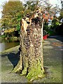
Tree stump, Ward Park
One of three tree stumps i a row at Ward Park, Bangor. Each appears to be covered in fungus.
Image: © Rossographer
Taken: 26 Oct 2008
0.10 miles
2
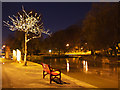
Ward Park, Bangor
Ward Park at night. The scene is mainly lit by the sodium streetlights although there is a faint hint of blue remaining in the sky. You should be able to make out the ghostly outlines of the resident geese Image on the river. Captured by the long exposure, they were disappointed when I failed to produce any bread.
Image: © Rossographer
Taken: 15 Nov 2010
0.10 miles
3
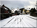
Moira Drive, Bangor
Moira Drive with a light dusting of snow. The street, formerly the site of Bangor Golf Club, was mainly developed in the 1930s when the club shifted to nearby Broadway. Many of the houses were badly damaged by bombers during WW2, a German pilot mistaking the golf course for an airfield.
Image: © Rossographer
Taken: 20 Dec 2009
0.10 miles
4
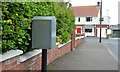
Drop box, Bangor
A drop box at the Moira Drive end of Magheralin Avenue.
Image: © Albert Bridge
Taken: 30 Jul 2013
0.10 miles
5
Frozen Ward Park, Bangor
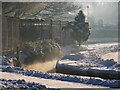
The river through Ward Park in Bangor http://www.geograph.org.uk/search.php?i=17814522 during the cold spell in December 2010. The night of 21st/22nd December was extremely cold in Bangor. This is a picture taken in the park on the morning of the 22nd - most of the water had frozen solid and there was a very hard frost with snow lying 3-4 inches deep on the ground.
Image: © Rossographer
Taken: 22 Dec 2010
0.10 miles
6
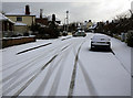
Moira Drive, Bangor
Moira Drive with a light dusting of snow. The street, formerly the site of Bangor Golf Club, was mainly developed in the 1930s when the club shifted to nearby Broadway. Many of the houses were badly damaged by bombers during WW2, a German pilot mistaking the golf course for an airfield.
Image: © Rossographer
Taken: 20 Dec 2009
0.11 miles
7
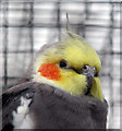
Cockatiel, Ward Park
As well as the many free to roam around the grounds, Ward Park in Bangor also has many exotic caged birds. This is a cockatiel. See also http://www.geograph.org.uk/search.php?i=5710082 for a variety of related images.
Image: © Rossographer
Taken: 17 Mar 2009
0.12 miles
8
Moira Drive, Bangor
Moira Drive in Bangor, just before midday on the 25th December 2019. The day itself in Bangor was glorious and ideal for walking after a hearty meal - bright, relatively mild and with no wind.
Compare this scene to one taken just over 10 years before at Image
Image: © Rossographer
Taken: 25 Dec 2019
0.12 miles
9
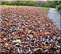
Fallen leaves, Ward Park
Fallen leaves in Ward Park. They had accumulated in this area up to a foot deep in places.
Image: © Rossographer
Taken: 24 Oct 2008
0.12 miles
10

Bench, Ward Park
A lonely bench in Ward Park, Bangor, sits surrounded by fallen leaves.
Image: © Rossographer
Taken: 2 Nov 2009
0.12 miles